Clee Hills from near Cleobury North
Shropshire Hills Walk
Region - Shropshire Hills
County/Area - Shropshire
Author - Lou Johnson
Length - 6.8 miles / 11 km Ascent - 700 feet / 212 metres
Time - 4 hours 10 minutes Grade - easy/mod
Walk Route Description
Click image to visit gallery of 3 images.
This walk visits the two summits that form the Clee Hills. Abdon Burf, the more northerly of the two is the highest hill in Shropshire. As such it offers some fine views over the surrounding countryside including the Long Mynd. Two kilometres south lies Clee Burf, some 30 metres lower, from where the view south over the rolling landscape of Shropshire is equally good.
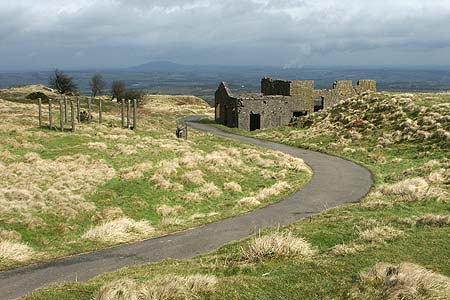
The start is the road side parking area alongside the lane at grid ref. SO607872 opposite the signed picnic area. Take the footpath that climbs steeply into the forest. The waymarks direct you uphill with the path crossing over two forestry access tracks to reach a further track at the top of Stanbroughs Woods (Grid ref. SO602865). The character of the woodland changes and the path crosses this track and passes through smaller trees and shrubs to reach a tarmac drive (Grid ref. SO596867) close by some ruined quarry buildings. Turn left along this drive past a pool on your left to arrive at the trig point at 540m. on Shropshire's highest hill. The views north-west and west are the best although by wandering about a little you can get a very good panorama that includes almost the full length of Wenlock Edge. Sadly the summits of Abdon Burf and Clee Burf are littered with radio masts and other modern hilltop 'junk'. However this does not in anyway detract from the view.
From the trig point descend on a clear path south-west. This leads down to the Shropshire Way (Grid ref. SO591862). Turn left and follow the clear path with a fence on your right as it descends to a col between the two hills (Grid ref. SO596853). The easiest way on to Clee Burf is to follow the boundary fence keeping it to your immediate left. There are other paths and these can be confusing and some lead you away from the summit. Reaching the summit, enjoy the view and then retrace your steps back to the col. Turn right down the enclosed bridleway. After 300 metres take the signed path on your right (Grid ref. SO599854). This leads down through open hillside to a bridleway alongside Bridge Pool (Grid ref. SO609855). Turn left along the bridleway keeping straight ahead. After approximately one mile you join a lane (Grid ref. SO610869). Go straight along this lane to reach the start with your transport parked on the right.
Maps 

| Ordnance Survey Explorer 217 | Sheet Map | 1:25k | BUY |
| Anquet OS Explorer 217 | Digital Map | 1:25k | BUY |
| Ordnance Survey Digital Map Subscription | |||
| Latest Ordnance Survey Discounts | |||
Other walks nearby
| Walk 2633 | Brown Clee Hill | easy/mod | 6.3 miles |
| Walk 2678 | Wenlock Edge & Broadstone | easy/mod | 6.4 miles |
| Walk 3334 | Titterstone Clee Hill and Catherton Common | easy/mod | 5.5 miles |
| Walk 2654 | Titterstone Clee Hill & Cleeton St. Mary from Cleehill | moderate | 7.5 miles |
| Walk 2022 | Wenlock Edge & Aston Munslow | moderate | 7.8 miles |
| Walk 3447 | Caer Caradoc, Hope Bowdler & Willstone Hills | moderate | 7.0 miles |
| Walk 2807 | The River Severn from Hampton Loade to Bridgnorth | easy/mod | 6.0 miles |
| Walk 3504 | Highley to Bewdley along the River Severn | easy/mod | 7.0 miles |
| Walk 1451 | Dudmaston Estate circular | easy | 4.0 miles |
| Walk 2092 | Highley from the Severn Valley Country Park | easy/mod | 4.5 miles |
Recommended Books & eBooks
Hillwalking in Shropshire
 Guidebook to 32 walking routes in Shropshire in the West Midlands. The routes range from 3 miles (5km) to 12 miles (19km), taking in highlights such as The Wrekin, Wenlock Edge, Long Mynd and Stiperstones, Castle Ring and Bury Ditches. Many routes start near delightful towns and villages including Church Stretton, Ludlow and Bishops Castle.
More information
