Kaim Hill & Fairlie Glen
North Ayrshire Walk
County/Area - North Ayrshire
Author - Lou Johnson
Length - 3.5 miles / 5.7 km Ascent - 1100 feet / 333 metres
Time - 2 hours 50 minutes Grade - moderate
Walk Route Description
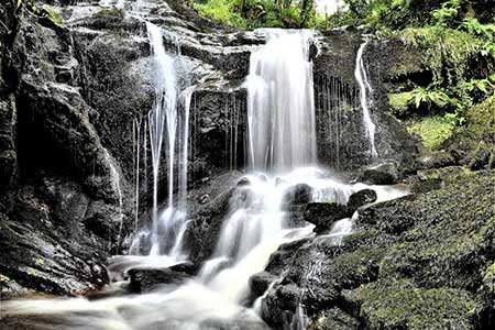
Click image to see photo description.
A short but energetic walk from Fairlie beginning by walking up Fairlie Glen with its waterfalls and the remains of a castle. The route the turns south to start a steady climb across wild moorland to the summit of Kaim Hill. Reward for your efforts is an outstanding view which includes the Ayrshire Coast, Great Cumbrae Island, the Isle of Arran dominated by the rocky outline of Goat Fell, the Isle of Bute and much more.
Limited parking is available at Fairlie railway station (grid ref. NS210546) which lies a short way off the A78 coastal road. After parking and with your back to the railway, turn left and follow a tarmac path from the northern end of the parking area. This path leads to Burnfoot Road. Bear right and then turn sharp right into Castlepark Drive. Where this road bends left, continue ahead onto a track signed as a cul-de-sac.
Continue up Fairlie Glen soon pass the partially restored ruins of Fairlie Castle. The path continues up Fairlie Glen through deciduous woodland with several waterfalls down to your right. The path, still climbing, soon reaches open moorland. Reaching a footbridge, cross Fairlie Burn onto the open hillside. The path, feint in places, heads steadily uphill over rough moorland. If in doubt, keep heading uphill. Reaching the summit of Kaim Hill (387 m) with its OS trig column, all the hard work is over, and you can now take time to enjoy the view. A useful accessory is a decent map which will help identify the highlights of the superb panorama.
To return to the start leave Kaim Hill by following the path down across the moor to the bridge over Fairlie Burn. Once across the bridge, turn left and retrace your steps down the glen back to the start.
Maps 

| Ordnance Survey Explorer 341 | Sheet Map | 1:25k | BUY |
| Anquet OS Explorer 341 | Digital Map | 1:25k | BUY |
| Ordnance Survey Digital Map Subscription | |||
| Latest Ordnance Survey Discounts | |||
Other walks nearby
| Walk 1115 | Goatfell, Isle of Arran | mod/hard | 9.0 miles |
| Walk 2347 | Duncryne from Gartocharn | easy | 2.0 miles |
| Walk 2552 | West Highland Way Experience | moderate | 95.0 miles |
| Walk 1490 | West Highland Way - A personal experience | moderate | 96.0 miles |
| Walk 1491 | WHW - Day 1 - Milngavie to Drymen | moderate | 12.0 miles |
| Walk 1296 | Beinn Eich & Doune Hill | mod/hard | 8.0 miles |
| Walk 2659 | Conic Hill | easy/mod | 4.0 miles |
| Walk 2765 | Conic Hill Circular | easy/mod | 7.0 miles |
| Walk 1492 | WHW - Day 2 - Dryden to Rowardennan | moderate | 15.0 miles |
| Walk 3009 | Ben Lomond | mod/hard | 7.5 miles |
