Sempringham Circular from Folkingham
Lincolnshire Walk
County/Area - Lincolnshire
Author - Lou Johnson
Length - 6.0 miles / 9.8 km Ascent - 250 feet / 76 metres
Time - 3 hours 20 minutes Grade - easy
Walk Route Description
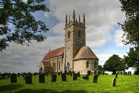
Click image to see photo description.
Starting from Folkngham this circular walk explores the countryside east of the village. The route crosses farmland on good paths and visits St. Andrew's church at Sempringham with its Holy Well. The walk also passes the remains of Folkingham Castle and Birthorpe Manor.
The walk starts from the centre of Folkingham where parking is available by the village green on the A15 (grid ref. TF072337). After parking walk south downhill and turn left into Billingborough Road. Continue past the entrance to Folkingham Castle on your left and bear right off the road at a fingerpost by metal gates. The path enters a field and runs beside the hedge on your left. The path continues with a drain on your left, crosses a footbridge and at the end of the field turns right again with a hedge on your left. Cross the footbridge and turn left along a clear track (grid ref. TF082331).
At the next junction bear left and continue along the track for just over a kilometre to Mareham Lane. Turn left and almost immediately right at a fingerpost to join the ongoing path. The path continues across two fields. Pass a small wood on your right and reaching the end of the field, turn right and follow the field edge to Birthorpe Road. Cross the road to a fingerpost opposite. The path initially runs beside a large barn on your left and then continues across fields crossing two small footbridges before reaching Sempringham Abbey (St, Andrew's) with its Holy Well (grid ref. TF107329).
Exit the churchyard at the southwest corner and cross a field to reach Marse Dyke. Turn right and after 250 metres continue ahead into the next field. Turn right along the hedge and after 50 metres turn half left to cross the field and continue to Mareham Lane. Turn right and almost immediately left to follow a signed path along the left-hand edge of a field. Just after passing a pond on your right, you reach a junction with a clearer track. Turn right and continue to the next junction (grid ref. TF084330). Rejoining the outward route, turn left and after 200 metres cross the small footbridge on the right and follow the path back into Folkingham. Reaching the road, turn left past the castle and then right on the A15 to return to the start.
Maps 

| Ordnance Survey Explorer 248 | Sheet Map | 1:25k | BUY |
| Anquet OS Explorer 248 | Digital Map | 1:25k | BUY |
| Ordnance Survey Digital Map Subscription | |||
| Latest Ordnance Survey Discounts | |||
Other walks nearby
| Walk 1026 | Ropsley, Scotland & the Humbys | easy/mod | 8.5 miles |
| Walk 2312 | Culverthorpe | easy | 4.0 miles |
| Walk 1429 | Sleaford riverside circular | easy | 6.4 miles |
| Walk 1437 | South Rauceby and Rauceby Hall | easy | 4.0 miles |
| Walk 1436 | High Wood and North Rauceby | easy | 4.8 miles |
| Walk 3284 | Bowthorpe Oak from Witham on the Hill | easy/mod | 8.0 miles |
| Walk 3312 | Woolsthorpe and Stenwith | easy | 3.7 miles |
| Walk 3512 | Scopwick, Kirkby Green & Blankney | easy | 7.3 miles |
| Walk 2663 | Moulton Marsh and The Welland from Fosdyke Bridge | easy/mod | 9.5 miles |
| Walk 1428 | Blankney Circular | easy | 3.8 miles |
