Airton & Bell Busk Circular
Yorkshire Dales Walk
Nat Park - Yorkshire Dales - Malhamdale
County/Area - North Yorkshire
Author - Lou Johnson
Length - 6.8 miles / 11.1 km Ascent - 700 feet / 212 metres
Time - 4 hours 10 minutes Grade - easy/mod
Maps 

| Ordnance Survey Explorer OL2 | Sheet Map | 1:25k | BUY |
| Anquet OS Explorer OL2 | Digital Map | 1:25k | BUY |
Walk Route Description
Click image to see photo description.
A delightful walk from the attractive village of Airton which lies near the southern boundary of the Yorkshire Dales National Park. The route follows the Pennine Way beside the infant River Aire before turning west across Haw Crag from where you can enjoy an excellent view. Reaching the small community of Bell Busk the walk turns north and follows a bridleway across Higher Colgarth Hill before a gentle descent back to Airton.
On-street parking is available by the village green in Airton (grid ref. SD902592). After parking walk east down Hellifield Road to cross the River Aire over a substantial stone bridge. Once over the river, turn right onto the Pennine Way signed to Gargrave. Follow the clear path, with the river on your right, for just over a kilometre to Newfield Bridge. Turn right across the river and then left onto the continuing Pennine Way. The easy-to-follow path leads south soon reaching a footbridge over the Aire. Cross the bridge and turn left staying on the Pennine Way which runs parallel to a road before trending half-left across Eshton Moor.
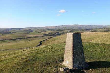
The next objective is Har Crag which rises to the right of the Pennine Way. The Pennine way soon reaches the end of a large field. Go through the gate and continue ahead for 350 metres to a feint cross path. Turn right and head up the gentle slope onto Haw Crag. From where the view north into the Yorkshire Dales National Park is excellent. After enjoying the vie join the clear track heading west. Which soon joins a walled track. Reaching a T-junction, turn right and follow the track which soon crosses the Aire and leads to a road (grid ref. SD905564).
Turn left and shortly after right (signed to Bell Busk). After 250 metres the road veers left. Fifty metres beyond this bend, turn right up a gravel track. There is bridleway sign on the adjacent telegraph pole. The track soon crosses a stream to a barn. Follow the track running in front of the barn ignoring the footpath off to the right. Just beyond the barn, the grassy tracks forks. Keep left and return to the grassy track along the left-hand edge of the field. Pass through a gate, pass a stand of trees, and continue ahead at the next gate. Pass another barn and keep ahead soon joining a walled track. Pass the extensive farm buildings at Kirk Syke on your left and walk ahead along a walled lane (Kirk Syke Lane). Continue to a road. Bear left and at the next junction turn right to return to Airton village and the end of the walk.
Other walks nearby
| Walk 1377 | Calton and Hanlith Moors | easy/mod | 6.5 miles |
| Walk 2066 | Winterburn Reservoir circular | easy | 6.0 miles |
| Walk 1051 | Gordale Scar & Malham Cove (Route 2) | moderate | 7.0 miles |
| Walk 1239 | Gordale Scar & Malham Cove | easy/mod | 6.5 miles |
| Walk 1274 | Nappa Cross & Malham | easy/mod | 5.5 miles |
| Walk 2602 | Gordale Scar & Malham Cove (Route 3) | moderate | 9.1 miles |
| Walk 2704 | Kirkby Malham & Hanlith from Malham | easy | 4.0 miles |
| Walk 2737 | The River Aire & Kirkby Malham from Malham | easy | 3.0 miles |
| Walk 3577 | Malham Cove from Malham | easy | 3.0 miles |
| Walk 3107 | Flasby Fell from Flasby | easy/mod | 6.5 miles |
Recommended Books & eBooks
Trail and Fell Running in the Yorkshire Dales
 Guidebook to 40 of the best trail and fell runs in the Yorkshire Dales National Park. Ranging from 5 to 24 miles, the graded runs start from bases such as Ribblehead, Dent, Sedbergh, Malham and Grassington and take in the region's diverse delights, from castles and waterfalls to iconic mountains such as Whernside, Ingleborough and Pen Y Ghent.
More information
Walking in the Yorkshire Dales: South and West
 Part of a two-book set, this guidebook describes 44 walks in the southern and western Yorkshire Dales, including the famous 23 mile Three Peaks circuit over Pen-y-Ghent, Whernside and Ingleborough. The other, mostly circular routes of 3½ to 13 miles cover the scenic region between Sedbergh, Kirkby Lonsdale, Settle, Skipton and Grassington.
More information
Messaging & Social Media
Message Walking Britain and follow the latest news.

Mountain Weather
Stay safe on the mountains with detailed weather forecasts - for iOS devices or for Android devices.