Malham Cove from Malham
Yorkshire Dales Walk
Nat Park - Yorkshire Dales - Malhamdale
County/Area - North Yorkshire
Author - Lou Johnson
Length - 3.0 miles / 4.9 km Ascent - 500 feet / 152 metres
Time - 2 hours 0 minutes Grade - easy
Walk Route Description
Click image to visit gallery of 3 images.
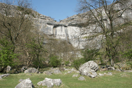
Malham Cove is one the most famous and most visited natural features in the Yorkshire Dales National Park. This short walk takes you to the bottom of the Cove and allows you to gaze up the limestone cliffs. There is also an option to climb to the top and enjoy the view down Malhamdale.
This Yorkshire Dales walk starts from the Visitor Centre (Grid ref SD900627) located on the approach to Malham. Exit the car park onto the main road and turn left into the village. Do not cross the river but continue straight ahead on the road walking out of the village. After approximately 600 metres take the footpath on the left signed Malham Cove. At busy times of the year you are unlikely to be alone, however in the evenings and off peak it is still possible to enjoy this valley in peace.
The footpath descends across fields towards the Cove. Continuing towards the bottom of the limestone cliffs you will pass a footbridge - take note as this will be used for the return route. Once in the Cove you have two options - either just view it from below or use the steps on your left to climb to the top. If you opt for the latter do be careful in wet weather as the limestone blocks on the top can be extremely slippery.
Whatever your choice, return to the footbridge and cross to the other side. This path is usually much quieter than the one used for the outward route and leads without any navigational problems back into the village. Reaching a lane, turn right, cross the river and bear left back to the car park.
Maps 

| Ordnance Survey Explorer OL2 | Sheet Map | 1:25k | BUY |
| Anquet OS Explorer OL2 | Digital Map | 1:25k | BUY |
| Ordnance Survey Digital Map Subscription | |||
| Latest Ordnance Survey Discounts | |||
Other walks nearby
| Walk 1282 | Malham Tarn & Arncliffe | moderate | 12.5 miles |
| Walk 3092 | Malham Cove, Malham Tarn & Watlowes | easy | 4.4 miles |
| Walk 2385 | Airton & Bell Busk Circular | easy/mod | 6.8 miles |
| Walk 1377 | Calton and Hanlith Moors | easy/mod | 6.5 miles |
| Walk 2066 | Winterburn Reservoir circular | easy | 6.0 miles |
| Walk 1701 | Bordley Hall & Malham Moor from Threshfield Moor | easy/mod | 7.0 miles |
| Walk 2332 | Mastilles Lane & Bordley from Kilnsey | easy/mod | 6.8 miles |
| Walk 3107 | Flasby Fell from Flasby | easy/mod | 6.5 miles |
| Walk 3109 | Rylstone Edges & Cracoe from Rylstone | easy/mod | 6.0 miles |
| Walk 2617 | Nappa Cross & Victoria Cave from Langcliffe | moderate | 9.5 miles |
Recommended Books & eBooks
Trail and Fell Running in the Yorkshire Dales
 Guidebook to 40 of the best trail and fell runs in the Yorkshire Dales National Park. Ranging from 5 to 24 miles, the graded runs start from bases such as Ribblehead, Dent, Sedbergh, Malham and Grassington and take in the region's diverse delights, from castles and waterfalls to iconic mountains such as Whernside, Ingleborough and Pen Y Ghent.
More information
Walking in the Yorkshire Dales: North and East
 This guidebook contains 43 circular day walks in the north and east Yorkshire Dales. It explores the dales, hills and moors between Kirkby Stephen and Pateley Bridge. Walking ranges from gentle 3 mile strolls to more strenuous day-long rambles across the Howgills, Wensleydale, Swaledale, Nidderdale, Mallerstang and Coverdale.
More information
