Walk 2398 - printer friendly version
Turville Circular Walk
Author - Lou Johnson
Length - 4.1 miles / 6.7 km
Ascent - 620 feet / 188 metres
Grade - easy
Start - OS grid reference SU768911
Lat 51.6135000 + Long -0.8922306
Postcode RG9 6QL (approx. location only)
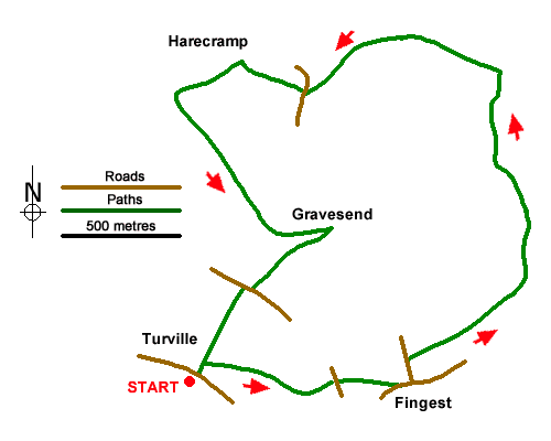
Circular walk exploring the Chiltern landscape north of the village of Turrville towards Cadmore End. The undulating route crosses open countryside and passes through woodland. The walk starts from the centre of Turville village (grid ref. SU768911) where parking is normally available near the village green.
Cross the green to a track between houses with an adjacent fingerpost. After a short distance turn right along the Chiltern Way. The route crosses a field and then runs along the edge of a small wood to reach Oxford Road. Go straight across into trees and fork right to follow the path into Fingest (grid ref. SU777911). Just past the church on your left, turn left along Chequers Lane. After 100 metres turn right along a signed enclosed footpath. After 100 metres fork right and continue along the right-hand edge of two fields to reach a track (grid ref. SU780914). Continue ahead for 300 metres and then fork left uphill following a waymarked bridleway. The route climbs gently for just over a kilometre through woodland.
Approaching Cadmore End you the track passes between hedges to reach a clear track by a small wood (grid ref. SU781925). Turn left and follow the path uphill. The path soon starts to descend and soon forks left into woodland as indicated by a waymark. Continue along the bridleway to reach Chequers Lane (grid ref. SU772924). Cross the lane to the stile opposite and head across the field to a stile. Cross the stile and turn left downhill along a clear track. The track leads to a green lane. Turn left and follow the green lane for just under a kilometre towards a lane at Gravesend (grid ref. SU774918).
Just before the lane, turn sharp right with yellow waymark. After 50 metres fork left and continue uphill through woodland to Oxford Road (grid ref. SU770915). Turn right past Cobstone Windmill and then left through a metal kissing gate. Follow the path steeply downhill back to Turville.
Messaging & Social Media
Message Walking Britain and follow the latest news.

Mountain Weather
Stay safe on the mountains with detailed weather forecasts - for iOS devices or for Android devices.