Walk 2419 - printer friendly version
Southease, Ditchling Beacon & Lewes Walk
Author - Peter Smyly
Length - 18.3 miles / 29.7 km
Ascent - 2100 feet / 636 metres
Grade - mod/hard
Start - OS grid reference TQ430054
Lat 50.830479 + Long 0.029187131
Postcode BN8 6JS (approx. location only)
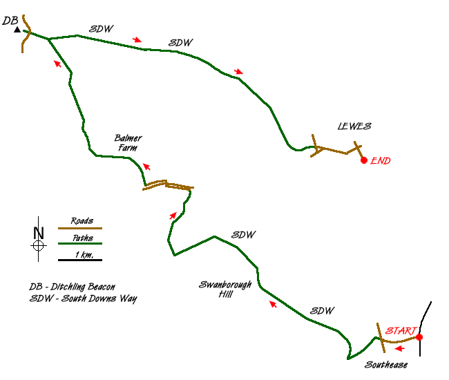
This is an East Sussex walk on the South Downs that starts at one rail station (Southease) and finishes at another (Lewes). The various roads, paths and tracks in the area provide the opportunity to make the walk shorter, if desired. In keeping with the South Downs generally, gradients are mostly gentle and the few sections that are steep, are only steep in a relative sense and tend to be only short in duration. The highest point reached is Ditchling Beacon (814 feet), the third highest point on the South Downs. It is a short walk from a National Trust car park for those who want the view from the top but without the effort. The route is generally clear with paths and sign posts.
Cross the bridge over the River Ouse and follow the road ahead to the East Sussex village of Southease, passing a church on the left as the road goes up a hill to a T junction. Turn right and, at the junction ahead, take a path beyond the road coming in from Telscombe to the left. This path leads down shortly to a valley where a wide track leads straight left towards Cricketing Bottom. Take the next path turning on the right, now going uphill reasonably steeply as you come to a crossroads at Mill Hill with a sign pointing right saying "To the pub". The walk follows the route straight ahead at the crossroads and a straight path gains height along the South Downs Way. In June 2011, a field ahead at the top of the rise was full of purple flowers. At this juncture (Swanborough Hill), you turn right to descend for a short distance before the path swings left to skirt the hillside with the field of purple flowers now on your left and views of the village of Kingston near Lewes down below with Lewes itself beyond. The latter part of the walk, the South Downs ridge can clearly be seen beyond on the horizon on the other side of the valley to the north.
Follow Jugg's Road (a track, not a road) with its isolated bushes and wind turbine before taking the path down the hill to the right towards Newmarket Plantation. This is a popular area with cyclists who you may see as they cycle up the hill here. There is a pleasant view back up to the ridge you have just walked along and cyclists may be seen moving along the skyline a bit like tiny ants. This may be considered a good spot to stop for a break. The South Downs to the east of Southease can also be seen from here as well as some white cliffs and a glimpse of the sea.
The route loses more height as the path goes down quite steeply in places through woodland before skirting a field and leading to an underpass beneath the railway line. Here turn left which brings you to a tarmac road which you follow before turning right over a bridge crossing the busy A27, the road then continuing to the left before a right turn leads up quite steeply in places to Balmer Farm.
Follow the bridleway north past the trigpoint on Balmer Huff and then after a short descent take the clear bridleway cutting sharply back left to join the lane at Moon's Corner. Turn right to go north on the lane and skirt the woods on the right, then take a path forking north-west past Stanmer Down. The path emerges on to open grassy hillside, leading up to the crest of the ridge between Home Brow and Western Brow. Ditchling Beacon is now clearly in view to the west and easily reached by a clear path, crossing a road to reach a car park and the trig point is then within easy reach. The path passes the top itself which is reached by a short digression, though the view from the top is much the same as from the path a little further down.
The way back to Lewes involves following the main path along the top of the Downs ridge roughly from west to east with the path being clear throughout. Take the right fork to miss out Harry's Place to follow the track down past a field with horses and show jumping activities into Lewes, passing the prison on the right. Follow the main road through Lewes before reaching the B2193 which leads down the hill to the right and Lewes station.
Messaging & Social Media
Message Walking Britain and follow the latest news.

Mountain Weather
Stay safe on the mountains with detailed weather forecasts - for iOS devices or for Android devices.