Southease, Ditchling Beacon & Lewes
South Downs Walk
Nat Park - South Downs
County/Area - East Sussex
Author - Peter Smyly
Length - 18.3 miles / 29.7 km Ascent - 2100 feet / 636 metres
Time - 11 hours 20 minutes Grade - mod/hard
Walk Route Description
Click image to visit gallery of 6 images.
This is an East Sussex walk on the South Downs that starts at one rail station (Southease) and finishes at another (Lewes). The various roads, paths and tracks in the area provide the opportunity to make the walk shorter, if desired. In keeping with the South Downs generally, gradients are mostly gentle and the few sections that are steep, are only steep in a relative sense and tend to be only short in duration. The highest point reached is Ditchling Beacon (814 feet), the third highest point on the South Downs. It is a short walk from a National Trust car park for those who want the view from the top but without the effort. The route is generally clear with paths and sign posts.
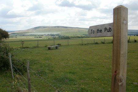
Cross the bridge over the River Ouse and follow the road ahead to the East Sussex village of Southease, passing a church on the left as the road goes up a hill to a T junction. Turn right and, at the junction ahead, take a path beyond the road coming in from Telscombe to the left. This path leads down shortly to a valley where a wide track leads straight left towards Cricketing Bottom. Take the next path turning on the right, now going uphill reasonably steeply as you come to a crossroads at Mill Hill with a sign pointing right saying "To the pub". The walk follows the route straight ahead at the crossroads and a straight path gains height along the South Downs Way. In June 2011, a field ahead at the top of the rise was full of purple flowers. At this juncture (Swanborough Hill), you turn right to descend for a short distance before the path swings left to skirt the hillside with the field of purple flowers now on your left and views of the village of Kingston near Lewes down below with Lewes itself beyond. The latter part of the walk, the South Downs ridge can clearly be seen beyond on the horizon on the other side of the valley to the north.
Follow Jugg's Road (a track, not a road) with its isolated bushes and wind turbine before taking the path down the hill to the right towards Newmarket Plantation. This is a popular area with cyclists who you may see as they cycle up the hill here. There is a pleasant view back up to the ridge you have just walked along and cyclists may be seen moving along the skyline a bit like tiny ants. This may be considered a good spot to stop for a break. The South Downs to the east of Southease can also be seen from here as well as some white cliffs and a glimpse of the sea.
The route loses more height as the path goes down quite steeply in places through woodland before skirting a field and leading to an underpass beneath the railway line. Here turn left which brings you to a tarmac road which you follow before turning right over a bridge crossing the busy A27, the road then continuing to the left before a right turn leads up quite steeply in places to Balmer Farm.
Follow the bridleway north past the trigpoint on Balmer Huff and then after a short descent take the clear bridleway cutting sharply back left to join the lane at Moon's Corner. Turn right to go north on the lane and skirt the woods on the right, then take a path forking north-west past Stanmer Down. The path emerges on to open grassy hillside, leading up to the crest of the ridge between Home Brow and Western Brow. Ditchling Beacon is now clearly in view to the west and easily reached by a clear path, crossing a road to reach a car park and the trig point is then within easy reach. The path passes the top itself which is reached by a short digression, though the view from the top is much the same as from the path a little further down.
The way back to Lewes involves following the main path along the top of the Downs ridge roughly from west to east with the path being clear throughout. Take the right fork to miss out Harry's Place to follow the track down past a field with horses and show jumping activities into Lewes, passing the prison on the right. Follow the main road through Lewes before reaching the B2193 which leads down the hill to the right and Lewes station.
Maps 

| Ordnance Survey Explorer OL11 | Sheet Map | 1:25k | BUY |
| Anquet OS Explorer OL11 | Digital Map | 1:25k | BUY |
| Ordnance Survey Digital Map Subscription | |||
| Latest Ordnance Survey Discounts | |||
Other walks nearby
| Walk 1770 | Southease or Rodmell to Falmer | easy/mod | 6.8 miles |
| Walk 1633 | Charleston Farm & Firle Beacon | easy/mod | 4.6 miles |
| Walk 1015 | Ouse Valley & Beddingham Hill | moderate | 12.0 miles |
| Walk 2684 | Falmer to Pyecombe & Blackcap by South Downs Way | moderate | 8.8 miles |
| Walk 3575 | High and Over White Horse | easy | 2.0 miles |
| Walk 3120 | Alfriston to Rodmell by the South Downs Way | moderate | 9.0 miles |
| Walk 3574 | Firle Beacon & Cuckmere Valley | moderate | 10.4 miles |
| Walk 2903 | Stanmer to Streat | moderate | 12.5 miles |
| Walk 1357 | The Seven Sisters from Exceat | moderate | 14.0 miles |
| Walk 2486 | Plumpton Green & South Downs | easy/mod | 7.7 miles |
Recommended Books & eBooks
Walks in the South Downs National Park
 Guidebook with 40 circular walks throughout the South Downs National Park, exploring the beautiful chalk hills between Eastbourne and Winchester. The walks range from under 5 miles to 11 miles, including Beachy Head and the Seven Sisters, Ditchling Beacon and hundreds of prehistoric sites. Accessible all year, but wild flowers best in spring.
More information
The South Downs Way
 Guidebook to walking the South Downs Way National Trail, a 100 mile (160km) route between Winchester and Eastbourne through the South Downs National Park, described in both directions over 12 stages. Easy walking on ancient and historical tracks, taking in wooded areas, delightful river valleys and pretty villages. With 1:25K OS map booklet.
More information
