Hever & Markbeech from Chiddingstone
Kent Walk
County/Area - Kent
Author - Lou Johnson
Length - 5.9 miles / 9.6 km Ascent - 350 feet / 106 metres
Time - 3 hours 20 minutes Grade - easy
Walk Route Description
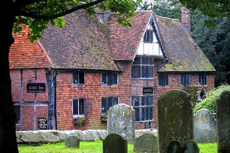
Click image to see photo description.
The Kent village of Chiddingstone is well-preserved and owned by the National Trust. Its Tudor buildings reflect the architecture of the period with the Castle Inn and Tulip Tree tearooms amongst the most memorable. On street parking is available (grid ref. TQ501451) although do remember to park considerately. The walk also provides the opportunity to visit Hever Castle.
After parking and exploring the village, take the footpath south that starts opposite Glebe House. After approximately 500 metres you reach a path junction (grid ref. TQ501446). Turn right here and continue to Hill Hoath Farm joining the Eden Valley Walk before you reach the farm. Walk past the farm and bear right onto a lane (grid ref. TQ497446). Turn left and continue following the Eden Valley Walk. After 400 metres bear right at a junction staying on the Eden Valley Walk which is followed to reach a lane (grid ref. TQ490446). Cross the road and continue following the Eden Valley Walk around the boundary of Park Wood and onto the road at Hever (grid ref. TQ476448).
Turn left along the road and almost immediately take the first lane on the left passing a school on your left. The path heads south, crosses a road (grid ref. TQ476444) and continues heading south to join a road (grid ref. TQ475437). Bear left along this road and follow for about a kilometre until your reach the crossroads in the centre of Markbeech (grid ref. TQ475427).
Turn left and walk east for 600 metres to reach a T-junction (grid ref. TQ481430). Go straight ahead here following a track through Newtye Hurst wood. After 2.5 km you reach Hill Hoath Farm from where you retrace your outward route back to the start in Chiddingstone village.
Maps 

| Ordnance Survey Explorer 147 | Sheet Map | 1:25k | BUY |
| Anquet OS Explorer 147 | Digital Map | 1:25k | BUY |
| Ordnance Survey Digital Map Subscription | |||
| Latest Ordnance Survey Discounts | |||
Other walks nearby
| Walk 2758 | Cowden Circular | moderate | 8.7 miles |
| Walk 2011 | Chartwell from Crockham Hill | easy | 2.8 miles |
| Walk 3441 | Sevenoaks, Seal Chart and Ightham Mote | moderate | 11.0 miles |
| Walk 2284 | Limpsfield Circular | easy/mod | 6.0 miles |
| Walk 1510 | Otford, Romney Street & Woodlands | moderate | 14.5 miles |
| Walk 1610 | Otford, Romney Street & Kemsing | mod/hard | 16.8 miles |
| Walk 2335 | Ashdown Forest & Nutley Windmill | easy/mod | 4.7 miles |
| Walk 3598 | Knockholt via Pratt's Bottom, Mace Farm and The Washneys | easy/mod | 7.3 miles |
| Walk 2156 | Lullingstone Castle Circular | easy | 4.0 miles |
| Walk 2333 | Lullingstone & Preston Hill near Shoreham (Kent) | easy/mod | 6.6 miles |
Recommended Books & eBooks
Walking in Kent
 A guidebook describing 40 walks in the county of Kent. Covering west Kent and The Weald and north and east Kent, including the Kent Downs and the Greensand Hills. Walks of 5 to 9 miles explore rivers and coastline, beautiful countryside and historic villages. With outlines of 11 longer walks ranging from 15 to 163 miles.
More information
