Walk 2437 - printer friendly version
Bowland Knotts Walk
Author - Lou Johnson
Length - 7.4 miles / 12 km
Ascent - 1200 feet / 364 metres
Grade - moderate
Start - OS grid reference SD702590
Lat 54.0261270 + Long -2.4563816
Postcode LA2 8HA (approx. location only)
The gritstone outcrops of Bowland Knotts lie on the Yorkshire and Lancashire border rising to nearly 500 metres above sea level. This route traverses some wild country and offers excellent views north to the Yorkshire Dales and the Three Peaks. The landscape is unforgiving in inclement weather and the route should only be attempted by experienced walkers with good navigational skills and appropriate maps.
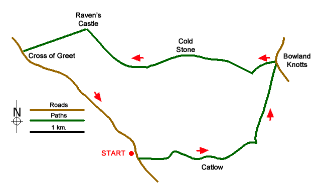
The start is the small parking area at Cross of Greet Bridge (grid ref. SD702590) on the minor road running north from the village of Slaidburn to Betham. After parking cross the road and continue across boggy ground with the slope to your left and the River Hodder to your right. Continue past the sheep pens (to your right), go through a gate and continue ahead. About 500 metres beyond the sheep pens turn right onto a farm track. Cross a stream and continue ahead. Turn left where the track forks and walk uphill above Catlow farm. Once over the bow of the rise, aim for a gate in a wall corner (grid ref. SD717589).
Careful navigation with the help of a 1:25000 map is now required. Head northwest to a wall corner and gate (grid ref. SD723592). Once through the gate follow the track heading east of north. Bowland Knotts soon comes into view. Continue along the track to reach a minor road (grid ref. SD726605).
Turn left along the road to the col which marks the Lancashire and North Yorkshire boundary. If you have time it is worth turning right off the road and exploring the crags of Bowland Knotts and the Hanging Stone before retracing tour steps back to the road. Otherwise turn left off the road along a rough track and follow the wall (on your left). This is a wonderful spot from which to enjoy the extensive panorama to the north. The route now heads roughly west. Descend slight to Copy Nook and continue uphill to Cold Stone (grid ref. SD710607).
With map in hand, continue west to reach Ravens Castle (grid ref. SD700606) where there is a wall on the left. Continue with the fence and eventually a wall on your left to Raven's Castle or Crowd Stones (grid ref. SD693612). Cross the stile at the fence/wall junction and walk downhill just south of west with the wall to your left. This leads down to the road at Cross of Greet (grid ref. SD682608). Turn left down the road towards Slaidburn. An easy downhill walk of about two miles takes you back to the start.
Messaging & Social Media
Message Walking Britain and follow the latest news.

Mountain Weather
Stay safe on the mountains with detailed weather forecasts - for iOS devices or for Android devices.