Walk 2450 - printer friendly version
Llynnau Cregennen & Mawddach Estuary Walk
Author - Lou Johnson
Length - 8.4 miles / 13.7 km
Ascent - 1400 feet / 424 metres
Grade - moderate
Start - OS grid reference SH640148
Lat 52.7137180 + Long -4.0147098
Postcode LL39 1YY (approx. location only)
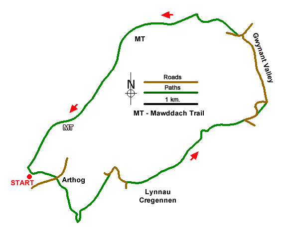
A varied circular walk from Arthog beside the Mawddach estuary. The route offers a wide variety of terrain and scenery including green woods with waterfalls, a stretch of open moorland, remote mountain lakes and great views. The walk concludes with a section of the Mawddach Trail which uses a disused former railway line beside the estuary.
The start is the car park at Arthog (grid ref. SH640148) on the north side of the A493. After parking take the path running southeast back to the main road. Turn left and continue past St Catherine's Church, on the left, to leave the road at a gate on the right. You now enter Arthog Woods. Initially the path climbs steeply using a series of stone steps. The path is easy to follow and is seldom far from the rushing water of a stream below. There are occasional waterfalls and cascades as you make progress uphill. After crossing a stile, the path soon leaves the trees and continues upstream to a clapper bridge (grid ref. SH650138).
Cross the bridge and initially follow a track which curves right around the hillside between walls. The onward path does become less distinct and is rough in places but leads across open moorland to a minor road (grid ref. SH655147). Turn right and head uphill. And as the Cregennen Lakes come into view there is a footpath sign on your left. It is worth heading down the roads a little further to get a better view. The larger of the two lakes has an attractive island with Cadair Idris forming a majestic backdrop.
Return to the footpath passed earlier and turn right. The path follows the shore of the larger lake and to your left rises the minor summit of Pared y Cefn Hîr. For a better a better view fork left and head up to the ridge before returning to this junction. The onward path enters a shallow valley and shortly before reaching a house at Ty'n-llidiart follow the white arrows through a field. You soon join a track which is followed to a lane (grid ref. SH680157). Turn left and continue along the lane to reach a small cemetery on your left. Fork right off the lane here and descend through trees to rejoin the lane in the Gwynant valley.
Continue ahead down the lane, soon passing the Youth Hostel on your right. You now have just over a kilometre of easy and pleasant walking to the A493. Turn left and almost turn right off the main road along a tarmac drive signed to Abergwynant Farm. Nearing the farm leave the drive and follow a riverside path down to the Mawddach estuary. Reaching the old railway line (now the Mawddach Trail) turn left and complete the easy 4.5 kilometres back to the start enjoying the glorious landscape of estuary and mountains.
Messaging & Social Media
Message Walking Britain and follow the latest news.

Mountain Weather
Stay safe on the mountains with detailed weather forecasts - for iOS devices or for Android devices.