Walk 2472 - printer friendly version
Abbeycwmhir Circular Walk
Author - Lou Johnson
Length - 7.2 miles / 11.7 km
Ascent - 1100 feet / 333 metres
Grade - easy/mod
Start - OS grid reference SO054713
Lat 52.3316040 + Long -3.3896911
Postcode LD1 6PH (approx. location only)
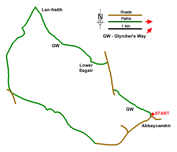
Walk from Abbeycwmhir named after Cwmhir Abbey, a Cistercian abbey built there in 1143. It was the largest abbey in Wales but was never completed. The Abbey was later slighted in 1644, during the English Civil War, although some ruins still remain. The route explores the hills, valleys and forests lying to the west of the village and follows a section of Glyndŵr's Way.
The walk starts from Abbeycwmhir where limited parking is available by the church entrance (grid ref. SO054713). With your back to the church, turn right along the road and ignore the footpath on the right. Keep left where the road forks and continue for a further 700 metres to where the main road bends sharp right. Continue ahead along a lane. After a kilometre you reach a house on the left (Lower Cwmhir). Alternative parking by kissing gate. Take the signed footpath on the right (grid ref. SO039706). Pass through the kissing gate and follow a grassy track which leads up the valley to some buildings at Upper Cwmhir.
Turn left on a rising path between hedges. Keep ahead at junction of tracks and soon enter an open field. Keep to the right-hand edge and continue into the next field. Maintain direction across this field to a stile to enter a plantation. The waymarked path continues to a forestry track. Bear right and soon after fork left off the track to reach a lane (grid ref. SO018719). Turn right and follow the upper lane which climbs steadily into the hills. Keep ahead at all junctions. The track passes through a plantation and exits onto open hillsides. At the edge of the plantation, ignore the track turning sharp right and walk ahead through a gate to follow a track.
Continue along the track to the next gate and just before the small plantation (grid ref. SO024741), turn right here to join Glyndŵr's Way. This long-distance path is well-waymarked and after crossing the flank of Llan-fraith the path follows the ridge of Upper Esgair Hill to start a descent into the valley. Approaching Upper Esgair Farm you join a clear track. Where the track bends right, continue ahead, and follow the path to rejoin the track later. Reaching Lower Esgair Far, follow the track as it bends left and continue down to a lane. Turn right and after 700 metres fork left to continue along Glyndŵrs Way. Descend to a footbridge and follow the waymarks through a planation back to the church in Abbeycwmhir.
Messaging & Social Media
Message Walking Britain and follow the latest news.

Mountain Weather
Stay safe on the mountains with detailed weather forecasts - for iOS devices or for Android devices.