Walk 2498 - printer friendly version
Gorllwyn circuit, Elan Valley Walk
Author - Paul Gasson
Length - 6.8 miles / 11 km
Ascent - 1430 feet / 433 metres
Grade - easy/mod
Start - OS grid reference SN901616
Lat 52.241579 + Long -3.6109648
Postcode LD6 5HF (approx. location only)
This walk explores the wild and remote plateau above the Elan Valley in Mid Wales. It is a walk for the lover of solitude and huge skies, and demands good navigational skills, being virtually devoid of paths in what has been referred to as the Green Desert of Wales, with considerable justification.
The Elan Valley dams, just outside the old town of Rhayader, were built between 1893 and 1952 to provide drinking water to Birmingham, which they do by a series of buried aqueducts some 126 Km. long, ensuring that the water reaches the treatment works in Birmingham entirely by gravity. At the time of it's construction the works were described as the 8th.Wonder of the World, and amongst the greatest civil engineering achievements in the UK. If the weather at the time of your visit precludes tackling this walk, a tour of the dams by car or mountain bike will provide a fascinating alternative, with many low level walks available.
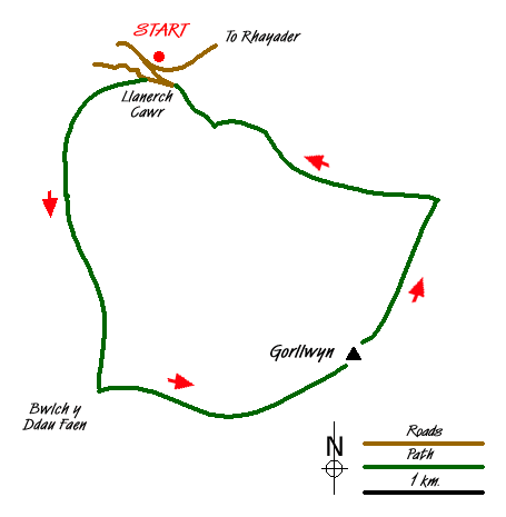
Take the B4518 from the centre of Rhayader, crossing the Wye and soon passing the Visitor Centre below the Caban Coch dam, worthy of a visit in it's own right. Take the first left turn to cross the bridge between the Caban Coch and Garreg Du reservoirs and follow the road to a car park at SN901616. Cross the road and the bridge opposite, bearing left towards Llanerch Cawr ( The Place of the Giant) before doubling back on yourself to take the lane towards Rhiwnant at the mouth of the Rhiwnant valley, which is steep sided. Where the lane veers right, go left on a clear track left which enters the steep sided valley, climbing steadily up above some cataracts and disused quarries. Don't cross the Rhiwnant but take the left fork in the track which leads into a side valley (Nant Dyrys) which translates as the difficult or tangled ravine. Ignore another track to the right and continue the steady climb up the valley, until the track takes a hairpin bend to the left to climb to the skyline. Ignore this and continue straight ahead on a vestigial path for another 2km. into Nant Paradwys, the Paradise ravine! Ignore another path to the right and you shortly arrive at Bwlch y Ddau Faen ( Pass of the two stones), a collection of boulders and a small spring (SN895587) and the Community Boundary. This boundary is marked by occasional concrete blocks, often buried in the long grass, which form the only guide on the ground to the next section of your walk. If the mists are down, and you are unsure of your navigational skills, turn back here!
Our way leaves the path here, turning NE to follow a broad ridge up to an unnamed spot height (562 m.) before heading just South of East to another spot height (566 m.). From up here it is immediately apparent why the area is known as the Green Desert, with rolling hills, all of much the same altitude, as far as one can see in every direction. Follow the Community boundary markers, (skirting round a boggy area to the right if necessary), along a more or less flat ridge towards your main objective, the summit of Gorllwyn (613 m.) some 1.5km distant. The whole of this plateau holds many Bronze Age sites, burial cairns and standing stones and even a Roman Marching Camp further North, on Esgair Perfedd. The going, though never steep, is difficult, with not a trace of a path, and through long grass. Take your time to enjoy the solitude, and search for the occasional Red Kite, the symbol of the area, which have been successfully re introduced, and a visit to the Red Kite feeding centre at Gigrin Farm just outside Rhayader is a must.
From the summit of Gorllwyn the boundary markers ( when you can find them!) lead NE along the vaguest of ridges, passing the tiny pool of Llyn y Ferlen to cross the parish boundary which is marked on the OS map. Just before a boggy area (Cnapiau'r Ferlen) at SN 925604 head just North of West (275 deg.True), dropping very gently down hill along the crest of a broad and vague ridge to the edge of the access land, which is marked by a fence. Here the direct route crosses three fences, but you will find it easier to go left along the fence line, following it down to a crossing track. Go left on this, crossing a stream on a bridge, and continue easily along to Llanerch Cawr and a return to the car park. (This last section is not a public right of way, and outside the access land, but we experienced no difficulties at all using it).
Messaging & Social Media
Message Walking Britain and follow the latest news.

Mountain Weather
Stay safe on the mountains with detailed weather forecasts - for iOS devices or for Android devices.