Walk 2518 - printer friendly version
Black Hill & Four Reservoirs from near Wessenden Head Walk
Author - Paul Webb
Length - 10.0 miles / 16.3 km
Ascent - 1190 feet / 361 metres
Grade - moderate
Start - OS grid reference SE076073
Lat 53.562263 + Long -1.8867324
Postcode HD9 4HP (approx. location only)
This is a very nice Peak District walk on a fine day with good open views of the Yorkshire valleys and the open expanses of moorland. It's a good mixture of erosion-saving stone paving for quicker progress and getting covered in peat moss for the rest. On a low cloud day it's better described as crossing a bog in the fog - an experience in itself!
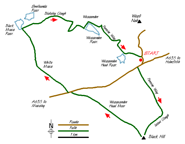
Park on the roadside on the A635 where it joins the Wessenden Head Road coming up from Meltham (Grid ref. SE076073). There's usually an excellent snack caravan here for a good start breakfast and a well earned tea and cakes at the end.
From the road, 50 yards SW of the junction take the signposted Pennine Way SSE on a stone flagged section which will take you all the way across Dean Clough and Black Dike and up the impressive Issue Clough to the peat bog which is Black Hill. At the OS trig. point on Black Hill (now well accessible because of the stone flagging) it may not be immediately obvious (especially in cloud) where the path starts for the next section, which is NW towards Dean Head Moss. You are safe to walk on a bearing from the trig. point keeping slightly to the right and you will find cairns and posts to assist. This is beautiful open moorland and is a lesser used path for those who prefer some solitude.
Crossing the A635 again at the car park (Grid ref. 051064) carry on NW across Featherbed Moss, White Moss and NNW to the southern point of Black Moss Reservoir. About one third of this section is stone flagged. The rest is in and out of peat bog with cairns and posts to assist route finding.
Here you join the Pennine Way again heading east past Swellands Reservoir on your left and down Blakely Clough. At Grouse Butts stay on the main path which contours southwest around delightful weirs and waterfalls and eventually down to cross the dam at Wessenden Reservoir.
Turn right once you are over the Dam and make sure you have saved some energy for a steady climb for the last one and a half miles up to Wessenden Head and the road back to your vehicle.
NOTE : I did a walk today which included part of the above route and found that the path from the foot of Blakely Clough around the weirs to the dam of Wessenden Res is currently closed because of subsidence.(OL1 Dark Peak map GR051085). The diversion is via the route now shown as the Pennine Way on the latest version of OL1. The details are: From the water tank at the foot of Blakely Clough (GR052088), bear left down the steep path to the bridge over Wessenden Brook. On the other side go up the path to join the Wessenden track at GR053090 and turn right to rejoin the original route at the Wessenden Reservoir dam adjacent to Wessenden Lodge." - Peter Schofield 9/11/2005
PS - Afterwards, if you have the time and energy, take the short permissive path from the Wessenden Head Road, for one mile north of the junction, up to West Nab for some splendid views.
Messaging & Social Media
Message Walking Britain and follow the latest news.

Mountain Weather
Stay safe on the mountains with detailed weather forecasts - for iOS devices or for Android devices.