East Meon to Old Winchester Hill Walk
Walk 2533 - Route Maps
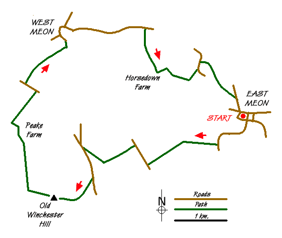
Route Map
Digital Maps - Copyright © 2011-2024. All rights reserved.
Sketch Map
Suggested Maps 

| Ordnance Survey Explorer OL3 | Sheet Map | 1:25k | BUY |
| Anquet OS Explorer OL3 | Digital Map | 1:25k | BUY |
| Ordnance Survey Explorer OL32 | Sheet Map | 1:25k | BUY |
| Anquet OS Explorer OL32 | Digital Map | 1:25k | BUY |
| Ordnance Survey Digital Map Subscription | |||
| Latest Ordnance Survey Discounts | |||
It is recommended you take a map. The preferred scale is 1:25k.
Start Point Details
Ordnance Survey Grid Ref SU678222
Latitude 50.995211 Longitude -1.035262
Postcode GU32 1NN
what3words start mouse.tidal.loss
Walk description may contain detailed information on the start point for this walk.
Further Information
South Downs
The South Downs is Britain's newest National Park and stretches from Winchester to Beachy Head. Steeped in history there are ancient hill-forts, barrows, a Roman road and deserted medieval villages. The area has a rich diversity of natural habitats including flower-studded chalk grassland, ancient woodland, flood meadow, lowland heath and the particularly rare chalk heathland. This varied environment provides an excellent basis for those who enjoy outdoor pursuits, such as walking, cycling and horse riding. South Downs Walking Guide
Walk grading - Learn how each walk is assessed and select a walk to suit your ability and experience by going to Walk Grading Details.
Messaging & Social Media
Message Walking Britain and follow the latest news.

Mountain Weather
Stay safe on the mountains with detailed weather forecasts - for iOS devices or for Android devices.