Walk 2542 - printer friendly version
Foel Grach & Llyn Eigiau Walk
Author - Nick O'Brien
Length - 8.5 miles / 13.8 km
Ascent - 2310 feet / 700 metres
Grade - moderate
Start - OS grid reference SH731662
Lat 53.177726 + Long -3.9002186
Postcode LL32 8SH (approx. location only)
The Carneddau include the largest area of land over three thousand feet in England and Wales and should therefore be treated with respect. Weather can change for the worse very quickly in these mountains and you should be adequately equipped and conversant with use of navigational aids.
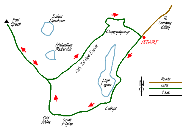
This Snowdonia (Eryri) walk starts at the car park (grid ref SH731662) which is reached by a narrow lane from the village of Tal-y-Bont in the Conway Valley. From the parking area walk southwest along the valley track past the reservoir of Llyn Eigiau to cross the river via a bridge made from old sleepers. Stay on the track to reach some old mine workings in Cwm Eigiau, which even in poor weather is a great place to be with crags and mountains in every direction.
From the old mine workings (grid ref. 703636) swing north following a clear path that climbs steadily across open mountainside with great views on your left to Carnedd Llewelyn, the highest point in the Carneddau. The path continues climbing with virtually no shelter in poor weather to reach the summit of Foel Grach, itself exceeding 3000ft altitude. Note that if the weather does do a turn for the worse, there is relative comfort to be found in a small stone shelter just east of the summit.
After taking in the views, which are superb in every direction retrace your steps as far as the broad, fairly flat area of Gledrffordd (grid ref. 700648). From here head north-westwards for the ridge of Cefn Tal-llyn-Eigiau. There is a path but it is easy to miss especially in its early stages although the superb views north to the Melynllyn and Dulyn Reservoirs with Foel Grach as a background soon make a path irrelevant.
Continue along the ridge to Clogwynyreryr from where a simple descent north leads you to pick up the track leading from Melynllyn Reservoir. Turn right along this track, which leads without further problem back to starting point.
Messaging & Social Media
Message Walking Britain and follow the latest news.

Mountain Weather
Stay safe on the mountains with detailed weather forecasts - for iOS devices or for Android devices.