Walk 2547 - printer friendly version
Carnedd Llewelyn from near Rowen Walk
Author - Nick O'Brien
Length - 12.0 miles / 19.5 km
Ascent - 3300 feet / 1000 metres
Grade - mod/hard
Start - OS grid reference SH720715
Lat 53.225076 + Long -3.9187938
Postcode LL32 8UR (approx. location only)
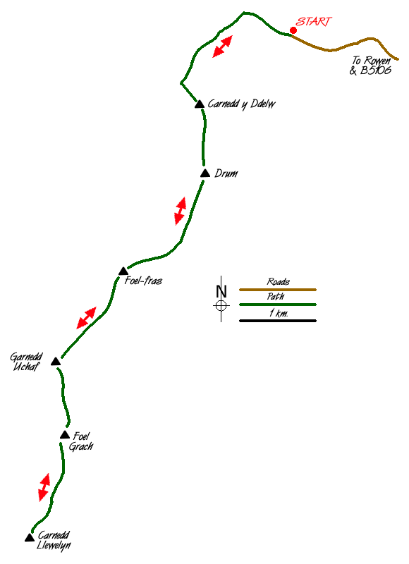
This a grand ridge route visiting many of the summits of the Eastern Carneddau and includes the highest point in this wonderful area of high mountains. To reach the start turn west off B5106 at Ty'n y Groes and continue through Rowen to the end of the road, where there is a small car park (Grid ref. SH720715). If possible choose a clear day as the views are excellent throughout.
After parking, follow the Roman Road northwest towards Bwlch y Ddeufaen for 500 metres or so. Turn left off the old road and follow the wall up a steep grassy first section leading to a fence. Continue in the general direction of the fence to the first summit of six during the walk namely Carnedd y Ddelw where the panoramic views in all directions start to take shape. To the north lies Anglesey and Puffin Island whilst to the south the next summit, Foel Fras, can be seen.
Drop down to the eroded track which takes you to the summit of Drum. Bear to the right and head for the path to the left of the reservoir. This takes you to the trig point at the top of Foel Fras. This is a good place to rest with a few sheltered spots among the rocks.
Ahead and still looking a mountain to climb are Foel Grach and Carnedd Llewelyn. The altitude already gained can be appreciated looking down on Anglesey and the Great Orme near Llandudno. Staying on the ridge continue on to Garnedd Uchaf, which is marked by a rock pile.
Down and up again - which is the story of the day and it continues as there is a lot of uphill on the way down - to Foel Grach where the panorama to the south starts to unfold. Dominating the scene is Carnedd Llewelyn, the highest peak in the Carneddau, and great views into the unwelcoming Cwm Caseg.
Carnedd Llewelyn is gained after a steep rocky incline opening up to a plateau and cairn on the summit. From here there are stunning views of Snowdon, the Glyders, Tryfan and the whole of the Carneddau Range with the added bonus of the North Wales Coast. The view from here makes the effort suddenly become worthwhile. The route back to the car is straightforward - just retrace your footsteps, though each leg seems to be a little longer on the way back.
Messaging & Social Media
Message Walking Britain and follow the latest news.

Mountain Weather
Stay safe on the mountains with detailed weather forecasts - for iOS devices or for Android devices.