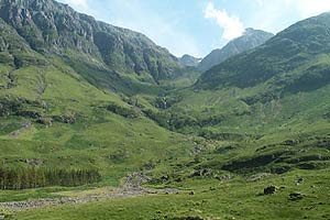
The Lost Valley, Glen Coe
Highland Walk
County/Area - Highland - Fort William Lochaber
Author - Mike Bexley
Length - 4.2 miles / 6.8 km Ascent - 1400 feet / 424 metres
Time - 3 hours 30 minutes Grade - easy/mod
Maps 

| Ordnance Survey Explorer 384 | Sheet Map | 1:25k | BUY |
| Anquet OS Explorer 384 | Digital Map | 1:25k | BUY |
| Ordnance Survey Landranger 41 | Sheet Map | 1:50k | BUY |
| Anquet OS Landranger 41 | Digital Map | 1:50k | BUY |
Walk Route Description
Click image to see photo description.
Although this is a very short low-level walk, this large hidden valley and the approach to it is worth the visit. Legends tell of stolen cattle and marauding gangs hiding in this valley. Just one word of caution. Early into the walk there is a ravine on the left of the path. My son slipped here and we nearly had a major problem. The rest of the walk presents no exceptional problems.
The start is from the viewpoint on the road through Glencoe (Grid ref. NN171568). Proceed down to the old military road turning left then right to drop down to the footbridge that can be seen from the start. Go over this bridge, which crosses over the Allt Doir-bheith, this place is named 'The Meeting of the Three Waters'.
Then follow the well-defined path that gradually climbs up the glen by the burn named Allt Coire Gabhail. At times this burns vanishes underground. Your first sight of the valley is amazing. You can continue to follow the feint path that runs up the valley to the foot of the mountains ahead or just explore the valley. It's certainly a beautiful place so don't rush back. Your return route is to retrace the path back.
Other walks nearby
| Walk 2955 | Ridges & peaks of Bidean Nam Bian | very hard | 10.5 miles |
| Walk 2808 | Buachaille Etive Beag, Glen Coe | hard | 9.0 miles |
| Walk 2819 | Stob na Broige, Buchaille Etive Mor, Glen Coe | mod/hard | 6.1 miles |
| Walk 1496 | WHW - Day 6 - Kinlocheven to Fort William | moderate | 15.0 miles |
| Walk 3010 | Stob Dearg (Buachaille Etive Mor) from Altnafeadh | mod/hard | 4.0 miles |
| Walk 3269 | The Munros of Buachaille Etive Mor | mod/hard | 8.2 miles |
| Walk 3118 | Sgor na h'Ulaidh from Achnachon, Glen Coe | mod/hard | 8.0 miles |
| Walk 3106 | Binnein Mor from Kinlochleven | hard | 10.2 miles |
| Walk 1039 | Am Bodach and Stob Coire a' Chairn | mod/hard | 9.5 miles |
| Walk 1094 | Blackwater Reservoir | moderate | 11.5 miles |
Recommended Books & eBooks
Skye's Cuillin Ridge Traverse
 This 2-volume set provides all the information required to complete the main ridge traverse on Skye's Black Cuillin. Strategy, gear, training, navigation and logistics are covered, and 10 classic scrambles are described. A lightweight second guidebook gives the scrambler detailed maps, topos and route description for the ridge traverse itself.
More information
Walking in Torridon
 This guidebook contains 52 day walks in Torridon, a remote and much-loved area of the Scottish Highlands. Based around Shieldaig and Slioch, the routes are split into 3 sections: easy walks, long and high level walks and mountain ascents over 2000ft including 9 Munros, and 5 outline suggestions for major ridge walks.
More information
Messaging & Social Media
Message Walking Britain and follow the latest news.

Mountain Weather
Stay safe on the mountains with detailed weather forecasts - for iOS devices or for Android devices.