The Disley Lanes from Lyme Park
Peak District Walk
Nat Park - Peak District - Goyt Valley Lyme Park
County/Area - Cheshire
Author - Mike Bexley
Length - 4.0 miles / 6.5 km Ascent - 500 feet / 152 metres
Time - 2 hours 30 minutes Grade - easy
Walk Route Description
Click image to visit gallery of 9 images.
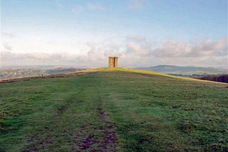
This short Peak District stroll from Lyme Park in Cheshire visits Lyme Cage prior to leaving the park. It then proceeds along quiet lanes before returning to the park. The Cage dominates the walk as it is rarely out of sight. Lyme Park is managed by the National Trust with a parking fee for non members. Also do check the closing time of the park. As a guide it closes at 6.30 pm in winter and 8.30 pm in the summer. The walk is easy to follow from this description and as there is no stiles it is dog friendly. Although this walk starts from the Lyme Park car park, you can also join it, as indicated from Disley Village or Railway Station.
Leave the car park (Grid ref. SJ962824) and climb the steps leading to the Hall's entrance. On reaching the gates to the Hall, climb up the short steep grass path slightly to the left of you. Alternatively you can proceed along the road ahead and take the first path up on your left. Both of these options lead you to a wide ridge with The Cage ahead. Considering you have not climbed very high, the views from this ridge are amazing. On your left surrounded by green grass is Woodford British Aerospace, further away Manchester Airport, Stockport and Manchester, with The Beetham Tower the highest residential property in Britain. In good visibility, Alderly Edge, North Wales and The Lakes are also visible. On your right, Kinder Scout with the Downfall dominates the distant skyline.
On reaching the Cage, thought to be a high place where the Ladies could watch their gentlemen hunting in the forest, continue walking down in the same direction. Just before the wide path, bear right and follow the grass path descending down to the corner of Horse Coppice Reservoir. Keep right close to the wall of what was once a Treatment Works but is now developed as accommodation. Cross over Bollinhurst Brook, never a problem, and keep to the feint footpath ahead. Bear right to go through the side gate next to the large gate on the right. Keep on this lane no doubt admiring the large houses. Then turn right into a similar lane.
(To reach this junction from Disley Station, climb the path ahead of you from the station. On reaching the lane turn right to the junction. From the village take the lane behind the Rams Head to the same junction.)
The lane climbs slightly passing a footpath sign on your left to the church. When the lane turns sharp right, walk straight onto Green Lane passing Bentside. This is a lovely stroll, again with views of the cage high on your right and the ground rising to Black Hill on your left. Pass Stoneridge Farm with its hopefully amusing warning sign against trespasses. On reaching the end of the lane there is a gate leading down to a small stream, again no problem. Then following the path to the gate into a lane, turn right. This boulder surfaced sheltered lane can get very wet at times. Descend down to Bollinhurst Bridge then up and on to East Gate Lodge leading back into the park. Continuing ahead leads you back to the start.
Maps 

| Ordnance Survey Explorer OL1 | Sheet Map | 1:25k | BUY |
| Anquet OS Explorer OL1 | Digital Map | 1:25k | BUY |
| Ordnance Survey Digital Map Subscription | |||
| Latest Ordnance Survey Discounts | |||
Other walks nearby
| Walk 2523 | Black Rocks & Bollinhurst Reservoir | easy | 5.0 miles |
| Walk 2567 | Lyme Park & Dissop Head | easy | 6.0 miles |
| Walk 2528 | Kettleshulme & Sponds Hill | moderate | 8.0 miles |
| Walk 2557 | Lyme Park from Poynton | moderate | 10.0 miles |
| Walk 2622 | Sett Valley & Kinder from New Mills | moderate | 10.0 miles |
| Walk 2605 | White Nancy & Saddle of Kerridge Nr Bollington | easy | 4.5 miles |
| Walk 3588 | Rainow Circular | easy/mod | 5.5 miles |
| Walk 1233 | Shining Tor & Windgather Rocks | moderate | 7.5 miles |
| Walk 2527 | Kettleshulme & Taxal Edge from Lamaload | moderate | 10.0 miles |
| Walk 2534 | Chinley Churn & South Head | easy/mod | 7.5 miles |
Recommended Books & eBooks
Dark Peak Walks
 Guidebook to 40 walks in the Dark Peak area of the Peak District National Park. 35 circular routes for most abilities, from 8km to 19km, around Edale, Marsden, Fairholmes, Baslow and Castleton, including Kinder Scout and Mam Tor, and 5 longer (25km to 45km) routes highlighting the best of the Gritstone Edges, High Moorland and Deep Valleys.
More information
Great Mountain Days in the Pennines
 An inspirational guidebook to 50 classic walks on the rolling Pennine landscape. The graded routes, between 6 and 13 miles in length, cover classic Pennine fells and moorland such as Whernside, Ilkley Moor and Pendle Hill; exploring the North and South Pennines, Yorkshire Dales, Howgills and Dark Peak. Many routes are also suited to fell running.
More information
