Walk 2568 - printer friendly version
Egmont Point & Kimmeridge Bay from Tyneham Walk
Author - Reg Carr
Length - 14.0 miles / 22.8 km
Ascent - 2300 feet / 697 metres
Grade - moderate
Start - OS grid reference SY882802
Lat 50.621384 + Long -2.1681662
Postcode BH20 5DE (approx. location only)
This is a walk with tremendous coastal views made even better because some of the paths are not open all the time as part of the walk is within the Bovington Tank Gunnery Range. At all times you must walk on the safe paths which are indicated by yellow-topped posts. Opening times are published on the following website Range Opening Times. Alternatively you can enquire at local Tourist Information Offices or see the Information Boards on the roads in the area.
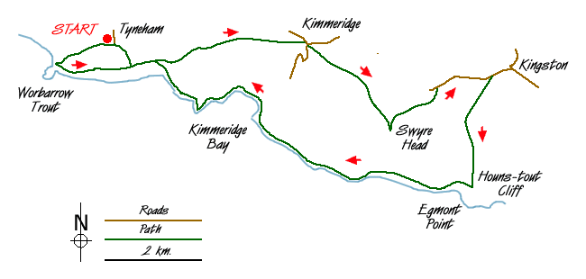
Start the walk at the Tyneham village car park (Grid ref. SY882802). Tyneham was evacuated in 1943 in the run up to D-Day and the villagers were never allowed back, so the village has an eerie feel. There is a small museum. Follow the track down to Worbarrow Bay (Grid ref. SY 870798), which is one of the most beautiful on this coast. You can get a good view from the top of the pointed headland, Worbarrow Tout, or as you climb up to Gad Cliff.
From the Bay head up the hill to the east to Gad Cliff - that is the path to the right with your back to the sea. Continue along the South West Coast Path to Tyneham Cap (Grid ref. SY 889797) and follow the higher path not the one which goes down the hill. You pass out of the ranges and there are good views down to Kimmeridge Bay on the right. At the secondary road (Grid ref. SY 919801) turn right then quickly left on the road and then after about 150 metres turn right up a track which climbs towards the coast. Where it joins a path on the ridge turn left and climb steadily up to Smedmore Hill and along a track which later becomes a then a path to reach Swyre Head (Grid ref. SY 934784). Enjoy the wonderful views along this path, perhaps stopping for a picnic as the views are hard to better.
From Swyre Head, take the path that heads north-east signposted 'car park & Kingston'. At the secondary road turn right and walk towards Kingston. Just after the car park turn right (Grid ref. SY 953795)and follow the track through the plantation that leads to Encombe House. Be careful to follow the footpath that branches off to the left and climbs gently up to the coast path at Houns-tout Cliff (Grid ref. SY 950773). From here there are good views of Encombe House and Encombe Dairy and across to Swyre Head.
Turn right (west) onto the South West Coast Path and follow this to Kimmeridge Bay. Care should be taken on this path as it is right on the cliff edge and take care to observe any diversions etc. that are in force because of cliff erosion.
Just before Kimmeridge Bay observe the folly 'Clavell's Tower' which featured in a PD James detective film. Walk across the car park and follow the coast path past the oil wells and back into the Gunnery Range. Climb steeply to Tyneham Cap (Grid ref. SY 889797) and walk west to Gad Cliff. Take the path on the right back to the village car park and the start of the walk.
Messaging & Social Media
Message Walking Britain and follow the latest news.

Mountain Weather
Stay safe on the mountains with detailed weather forecasts - for iOS devices or for Android devices.