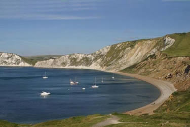
Egmont Point & Kimmeridge Bay from Tyneham
Jurassic Coast Walk
Region - Jurassic Coast
County/Area - Dorset
Author - Reg Carr
Length - 14.0 miles / 22.8 km Ascent - 2300 feet / 697 metres
Time - 9 hours 20 minutes Grade - moderate
Walk Route Description
Click image to visit gallery of 3 images.
This is a walk with tremendous coastal views made even better because some of the paths are not open all the time as part of the walk is within the Bovington Tank Gunnery Range. At all times you must walk on the safe paths which are indicated by yellow-topped posts. Opening times are published on the following website Range Opening Times. Alternatively you can enquire at local Tourist Information Offices or see the Information Boards on the roads in the area.
Start the walk at the Tyneham village car park (Grid ref. SY882802). Tyneham was evacuated in 1943 in the run up to D-Day and the villagers were never allowed back, so the village has an eerie feel. There is a small museum. Follow the track down to Worbarrow Bay (Grid ref. SY 870798), which is one of the most beautiful on this coast. You can get a good view from the top of the pointed headland, Worbarrow Tout, or as you climb up to Gad Cliff.
From the Bay head up the hill to the east to Gad Cliff - that is the path to the right with your back to the sea. Continue along the South West Coast Path to Tyneham Cap (Grid ref. SY 889797) and follow the higher path not the one which goes down the hill. You pass out of the ranges and there are good views down to Kimmeridge Bay on the right. At the secondary road (Grid ref. SY 919801) turn right then quickly left on the road and then after about 150 metres turn right up a track which climbs towards the coast. Where it joins a path on the ridge turn left and climb steadily up to Smedmore Hill and along a track which later becomes a then a path to reach Swyre Head (Grid ref. SY 934784). Enjoy the wonderful views along this path, perhaps stopping for a picnic as the views are hard to better.
From Swyre Head, take the path that heads north-east signposted 'car park & Kingston'. At the secondary road turn right and walk towards Kingston. Just after the car park turn right (Grid ref. SY 953795)and follow the track through the plantation that leads to Encombe House. Be careful to follow the footpath that branches off to the left and climbs gently up to the coast path at Houns-tout Cliff (Grid ref. SY 950773). From here there are good views of Encombe House and Encombe Dairy and across to Swyre Head.
Turn right (west) onto the South West Coast Path and follow this to Kimmeridge Bay. Care should be taken on this path as it is right on the cliff edge and take care to observe any diversions etc. that are in force because of cliff erosion.
Just before Kimmeridge Bay observe the folly 'Clavell's Tower' which featured in a PD James detective film. Walk across the car park and follow the coast path past the oil wells and back into the Gunnery Range. Climb steeply to Tyneham Cap (Grid ref. SY 889797) and walk west to Gad Cliff. Take the path on the right back to the village car park and the start of the walk.
Maps 

| Ordnance Survey Explorer OL15 | Sheet Map | 1:25k | BUY |
| Anquet OS Explorer OL15 | Digital Map | 1:25k | BUY |
| Ordnance Survey Digital Map Subscription | |||
| Latest Ordnance Survey Discounts | |||
Other walks nearby
| Walk 1331 | Kimmeridge & Tyneham | easy/mod | 6.8 miles |
| Walk 1534 | Swyre Head & Tyneham Cap from Kimmeridge | moderate | 11.8 miles |
| Walk 1995 | Houns-tout & Swyre Head from Kimmeridge | moderate | 8.7 miles |
| Walk 1004 | Durdle Door & Lulworth Cove | easy | 2.5 miles |
| Walk 1329 | Durdle Door & White Nothe from Lulworth Cove | moderate | 7.0 miles |
| Walk 3389 | Bindon Hill and the Fossil Forest from Lulworth | easy/mod | 4.0 miles |
| Walk 2145 | Houns-tout Cliff from Kingston | easy | 3.5 miles |
| Walk 2925 | St Aldhelm's Head near Worth Matravers | easy | 4.1 miles |
| Walk 3286 | Dancing Ledge & Durlston Head from Langton Matravers | easy/mod | 7.0 miles |
| Walk 2575 | Durdle Door & Lulworth Cove | moderate | 10.0 miles |
Recommended Books & eBooks
South West Coast Path Map Booklet - Minehead to St Ives
 Map of the northern section of the 630 mile (1014km) South West Coast Path National Trail. Covers the trail from Minehead to St Ives along the north Devon and Cornish coastline. This convenient and compact booklet of Ordnance Survey 1:25,000 maps shows the route, providing all of the mapping you need to walk the trail in either direction.
More information
The South West Coast Path
 Guidebook to walking the entire South West Coast Path National Trail. The route runs for 630 miles from Minehead to Poole along the north Devon, Cornish, south Devon and Dorset coastline. Divided into 45 stages, this long-distance coastal trek could be completed within 4 weeks, or walked in sections. Guide includes maps and essential information.
More information
