Durdle Door & Lulworth Cove
Jurassic Coast Walk
Region - Jurassic Coast
County/Area - Dorset
Author - Reg Carr
Length - 10.0 miles / 16.3 km Ascent - 2200 feet / 667 metres
Time - 7 hours 10 minutes Grade - moderate
Maps 

| Ordnance Survey Explorer OL15 | Sheet Map | 1:25k | BUY |
| Anquet OS Explorer OL15 | Digital Map | 1:25k | BUY |
| Ordnance Survey Landranger 194 | Sheet Map | 1:50k | BUY |
| Anquet OS Landranger 194 | Digital Map | 1:50k | BUY |
Walk Route Description
Click image to visit gallery of 4 images.
From Weymouth take the A353 and after Osmington turn right to Upton and on to the South Down car park (Grid ref. SY759823). Park on the left side of the track. From South Down car park, which has good views over Weymouth Bay to Portland, walk east along the track and onto a secondary road. Where road bends to the right, with a house in the middle distance directly ahead, take the left of two stiles by the gate and follow track down past a barn and on up the hill.
The track eventually becomes a path and turns left and you should follow this towards the coast. After a stile with an information board on the seaward side angle left down the slope towards the South West Coast Path, which you join after crossing another stile (Grid ref. SY780809). You should see a large conical marker to your left on the hill above you. Follow the path to the east and, when the path divides, take the path to the right, which goes down the slope towards the sea. This path has some steep descents and ascents and if you prefer a more level walk you should take the left path which hugs the contours above the sea. The views however are fantastic on the coast path and well worth the more strenuous walk.
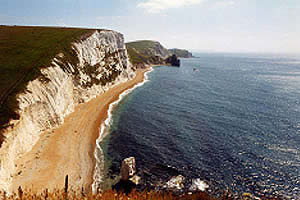
Follow the coast path to Durdle Door (Grid ref. SY805803) observing the superb views of the sheer chalk cliffs from Bat Head, which is about half-way to Durdle Door. The path goes very close to the cliff edge so be careful to keep well back from the edge particularly if there is a strong or blustery wind. At Durdle Door (a limestone arch) you can descend to the beach and this is an ideal spot for a picnic and/or a swim.
Continue along the coast path to Lulworth Cove (Grid ref. SY824799). There is a Visitor Centre and full facilities available in the village. Lulworth Cove is a very scenic completely circular cove. Stair Hole nearby is a 'young' example of the same. To the east of the cove is a fossil forest easily seen from the coast path.
From the centre of Lulworth proceed north up the secondary road towards West Lulworth and, after about 300 metres from the main car park, take the footpath on the left of the road (Grid ref. SY821803). Proceed across the field and up to a set of steps through some bushes. Then turn right and follow the path up the slope to the caravan park in the trees ahead (Grid ref. SY811805).
After the stile turn to the right and go through the caravan park towards the entrance and out up the drive to Newlands Farm (Grid ref. SY810810). Turn left and pass between the barn and the farmhouse, taking the footpath on the left signposted 'Ringstead'. Follow this path westwards for more than 2 miles until you see two conical markers. After this you will see a stone signpost which indicates the coast path goes straight on to White Nothe and Ringstead and the path to South Down car park goes off over the stile to the right. Take the path to the right and follow this back to the car park.
Other walks nearby
| Walk 1889 | White Nothe from Ringstead Bay | easy/mod | 5.8 miles |
| Walk 1597 | The White Horse & Sutton Poyntz from Osmington | easy/mod | 4.0 miles |
| Walk 2440 | White Nothe & Moigns Down from Osmington | moderate | 10.5 miles |
| Walk 1004 | Durdle Door & Lulworth Cove | easy | 2.5 miles |
| Walk 1329 | Durdle Door & White Nothe from Lulworth Cove | moderate | 7.0 miles |
| Walk 3389 | Bindon Hill and the Fossil Forest from Lulworth | easy/mod | 4.0 miles |
| Walk 2568 | Egmont Point & Kimmeridge Bay from Tyneham | moderate | 14.0 miles |
| Walk 1533 | Gad Cliff, Povington Hill & Tyneham | easy/mod | 4.5 miles |
| Walk 3748 | Southover Heath from Tolpuddle | easy | 5.0 miles |
| Walk 2370 | The Fleet from Langton Herring | easy/mod | 7.0 miles |
Recommended Books & eBooks
South West Coast Path Map Booklet - St Ives to Plymouth
 Map of part of the southern section of the 630 mile (1014km) South West Coast Path National Trail. Covers the trail from St Ives to Plymouth along the west Cornwall and Devon coastline. This convenient and compact booklet of Ordnance Survey 1:25,000 maps shows the route, providing all of the mapping you need to walk the trail in either direction.
More information
The South West Coast Path
 Guidebook to walking the entire South West Coast Path National Trail. The route runs for 630 miles from Minehead to Poole along the north Devon, Cornish, south Devon and Dorset coastline. Divided into 45 stages, this long-distance coastal trek could be completed within 4 weeks, or walked in sections. Guide includes maps and essential information.
More information
Messaging & Social Media
Message Walking Britain and follow the latest news.

Mountain Weather
Stay safe on the mountains with detailed weather forecasts - for iOS devices or for Android devices.