Durdle Door & Lulworth Cove
Jurassic Coast Walk
Region - Jurassic Coast
County/Area - Dorset
Author - Lou Johnson
Length - 2.5 miles / 4.1 km Ascent - 800 feet / 242 metres
Time - 2 hours 0 minutes Grade - easy
Walk Route Description
Click image to visit gallery of 3 images.
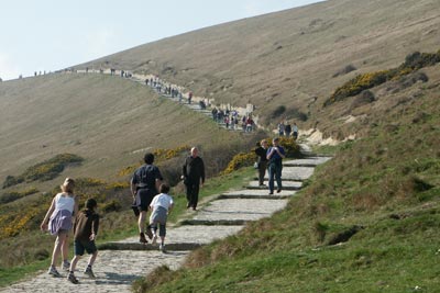
Durdle Door is a natural arch and is a well-know feature of the Jurassic Coast. This easy walk starts from Lulworth Cove, a circular coastal inlet, and follows a good path. For a longer walk including these two features walk 2575 is a more challenging route.
The start is the main car park next to the visitor centre at Lulworth Cove(Grid ref. SY 821800). This can be a very busy place during peak times and if you prefer a quiet walk then do avoid peak holiday periods. From the car park take the broad paved path heading uphill westwards towards the coast. All the height gained on this section will be lost as you descend to Durdle Door and as you have guessed will have to be climbed again to return to Lulworth Cove.
Reaching the summit of the first hill you get the first good view of the Dorset Coast with its fine white cliffs. Stay on the main South west Coast Path to reach Durdle Door where you can descend to the beach to get a better view of the rock arch.
To complete the walk return by the outward route to the car park continuing past the information centre to reach the shingle beach of Lulworth Cove. Almost completely circular the cove provides a sheltered haven for small boats and is a pleasant place to spend some time before returning to the start of the walk.
Maps 

| Ordnance Survey Explorer OL15 | Sheet Map | 1:25k | BUY |
| Anquet OS Explorer OL15 | Digital Map | 1:25k | BUY |
| Ordnance Survey Digital Map Subscription | |||
| Latest Ordnance Survey Discounts | |||
Other walks nearby
| Walk 2568 | Egmont Point & Kimmeridge Bay from Tyneham | moderate | 14.0 miles |
| Walk 1533 | Gad Cliff, Povington Hill & Tyneham | easy/mod | 4.5 miles |
| Walk 2575 | Durdle Door & Lulworth Cove | moderate | 10.0 miles |
| Walk 1889 | White Nothe from Ringstead Bay | easy/mod | 5.8 miles |
| Walk 1331 | Kimmeridge & Tyneham | easy/mod | 6.8 miles |
| Walk 1534 | Swyre Head & Tyneham Cap from Kimmeridge | moderate | 11.8 miles |
| Walk 1995 | Houns-tout & Swyre Head from Kimmeridge | moderate | 8.7 miles |
| Walk 1597 | The White Horse & Sutton Poyntz from Osmington | easy/mod | 4.0 miles |
| Walk 2440 | White Nothe & Moigns Down from Osmington | moderate | 10.5 miles |
| Walk 2145 | Houns-tout Cliff from Kingston | easy | 3.5 miles |
Recommended Books & eBooks
The South West Coast Path
 Guidebook to walking the entire South West Coast Path National Trail. The route runs for 630 miles from Minehead to Poole along the north Devon, Cornish, south Devon and Dorset coastline. Divided into 45 stages, this long-distance coastal trek could be completed within 4 weeks, or walked in sections. Guide includes maps and essential information.
More information
South West Coast Path Map Booklet - St Ives to Plymouth
 Map of part of the southern section of the 630 mile (1014km) South West Coast Path National Trail. Covers the trail from St Ives to Plymouth along the west Cornwall and Devon coastline. This convenient and compact booklet of Ordnance Survey 1:25,000 maps shows the route, providing all of the mapping you need to walk the trail in either direction.
More information
