Walk 2587 - printer friendly version
Castlerigg Stone Circle & St John's in the Vale Walk
Author - Mike Bexley
Length - 8.5 miles / 13.8 km
Ascent - 1200 feet / 364 metres
Grade - easy/mod
Start - OS grid reference NY282223
Lat 54.590767 + Long -3.1126513
Postcode CA12 4TE (approx. location only)
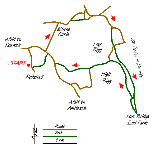
This is a lovely Lake District walk at the foot of a quiet valley with views all the way. It is beautiful at any time of the year. The route is easy to follow along good paths and can be cut short in many places. If you wish to extend the walk I suggest you turn left at Low Bridge End Farm, returning to St. John's Church and Youth Centre via Legburthwaite and High Rigg.
The walk starts from a narrow lane serving a hotel and caravan/camping site. Note that there is very limited parking in this lane but there is also limited parking on route at The Stone Circle and St. John's Church. Footpaths from Keswick Town also lead to the start.
Start using the footpath near Castlerigg Farm (Grid ref. NY282223) proceeding in a north east direction towards the mass of Blencathra in the distance. Cross over the main road and walk up Castle Lane opposite. This takes you to The Stone Circle. Cross over the stone stile on the right into the enclosure to take a closer look of these old stones.
Exit the enclosure via one of the three gates on your left turning right down the lane. Then take the footpath on the right opposite Goosewell Farm dropping down the field to the left hand corner to cross over Naddle Bridge (Grid ref. 300238). Follow the road right, passing a road joining from the left, and take the next lane on the right. This road drops down passing a quarry on the right to Shundraw. Go through the gate on the right of the building to follow a wall on your left, then over the wall via walker friendly steps. The path crosses over the wet fields through Row End joining a lane at Yew Tree Farm (Grid ref. 308230).
The walk can be cut short here, by turning right up the lane to St Johns Church and picking up the returning route. Those avoiding the short cut will be rewarded with a lovely valley walk following St John's Beck.
Turn left along the lane then right at the footpath sign. The path continues in a straight direction to left of Bridge House then to the right of the Beck. This is no time to hurry. The Beck curves away from the path leaving you to cross many fields with High Rigg on the right and Clough Head with Bramcrag Quarry on your left. If the path is feint look out to pass a sheep pen (with its narrow sheep gate), a double finger post sign and just after a bridge over a ditch, head for the left hand corner of the field to follow a fence on the left to the bank of St John's Beck. Pass Sosgill Bridge over the Beck and, still keeping to the right bank, continue to Low Bridge End Farm and through a gate in the wall (Grid ref. 317205).
Turn right and follow the path, part of which used to be a Coffin Route. Ahead of you is Blencathra and in the valley to your right the path you used for the outward route. The path ends at a lane (Grid ref, 307225). Turn left passing St. John's Church, then a Youth Centre. Continue onto a bridleway dropping rapidly down to a footpath across the fields ahead (Grid ref. 301223).
The footpath crosses over fields and a narrow footbridge eventually ending at a footpath T-junction (Grid ref. 294222). Turn right up to the wall and go through the first gate. Keep close to the right hand fence to the corner. Then go left over the wall and straight ahead to the main road. Turn right up the road (pavement on other side) and take the next footpath on your left back to your start.
Messaging & Social Media
Message Walking Britain and follow the latest news.

Mountain Weather
Stay safe on the mountains with detailed weather forecasts - for iOS devices or for Android devices.