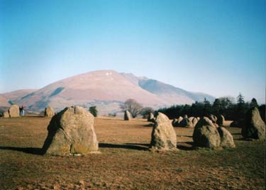
Castlerigg Stone Circle & St John's in the Vale
Lake District Walk
Nat Park - Lake District - Lake District Central Fells
County/Area - Cumbria
Author - Mike Bexley
Length - 8.5 miles / 13.8 km Ascent - 1200 feet / 364 metres
Time - 5 hours 30 minutes Grade - easy/mod
Walk Route Description
Click image to visit gallery of 2 images.
This is a lovely Lake District walk at the foot of a quiet valley with views all the way. It is beautiful at any time of the year. The route is easy to follow along good paths and can be cut short in many places. If you wish to extend the walk I suggest you turn left at Low Bridge End Farm, returning to St. John's Church and Youth Centre via Legburthwaite and High Rigg.
The walk starts from a narrow lane serving a hotel and caravan/camping site. Note that there is very limited parking in this lane but there is also limited parking on route at The Stone Circle and St. John's Church. Footpaths from Keswick Town also lead to the start.
Start using the footpath near Castlerigg Farm (Grid ref. NY282223) proceeding in a north east direction towards the mass of Blencathra in the distance. Cross over the main road and walk up Castle Lane opposite. This takes you to The Stone Circle. Cross over the stone stile on the right into the enclosure to take a closer look of these old stones.
Exit the enclosure via one of the three gates on your left turning right down the lane. Then take the footpath on the right opposite Goosewell Farm dropping down the field to the left hand corner to cross over Naddle Bridge (Grid ref. 300238). Follow the road right, passing a road joining from the left, and take the next lane on the right. This road drops down passing a quarry on the right to Shundraw. Go through the gate on the right of the building to follow a wall on your left, then over the wall via walker friendly steps. The path crosses over the wet fields through Row End joining a lane at Yew Tree Farm (Grid ref. 308230).
The walk can be cut short here, by turning right up the lane to St Johns Church and picking up the returning route. Those avoiding the short cut will be rewarded with a lovely valley walk following St John's Beck.
Turn left along the lane then right at the footpath sign. The path continues in a straight direction to left of Bridge House then to the right of the Beck. This is no time to hurry. The Beck curves away from the path leaving you to cross many fields with High Rigg on the right and Clough Head with Bramcrag Quarry on your left. If the path is feint look out to pass a sheep pen (with its narrow sheep gate), a double finger post sign and just after a bridge over a ditch, head for the left hand corner of the field to follow a fence on the left to the bank of St John's Beck. Pass Sosgill Bridge over the Beck and, still keeping to the right bank, continue to Low Bridge End Farm and through a gate in the wall (Grid ref. 317205).
Turn right and follow the path, part of which used to be a Coffin Route. Ahead of you is Blencathra and in the valley to your right the path you used for the outward route. The path ends at a lane (Grid ref, 307225). Turn left passing St. John's Church, then a Youth Centre. Continue onto a bridleway dropping rapidly down to a footpath across the fields ahead (Grid ref. 301223).
The footpath crosses over fields and a narrow footbridge eventually ending at a footpath T-junction (Grid ref. 294222). Turn right up to the wall and go through the first gate. Keep close to the right hand fence to the corner. Then go left over the wall and straight ahead to the main road. Turn right up the road (pavement on other side) and take the next footpath on your left back to your start.
Maps 

| Ordnance Survey Explorer OL4 | Sheet Map | 1:25k | BUY |
| Anquet OS Explorer OL4 | Digital Map | 1:25k | BUY |
| Ordnance Survey Explorer OL5 | Sheet Map | 1:25k | BUY |
| Anquet OS Explorer OL5 | Digital Map | 1:25k | BUY |
| Ordnance Survey Digital Map Subscription | |||
| Latest Ordnance Survey Discounts | |||
Other walks nearby
| Walk 1356 | Walla Crag | easy/mod | 4.5 miles |
| Walk 3029 | Derwentwater & Walla Crag | easy/mod | 6.5 miles |
| Walk 3037 | High Seat & Bleaberry Fell from Keswick | moderate | 9.0 miles |
| Walk 2321 | Shores of Derwentwater | easy | 3.5 miles |
| Walk 1073 | Skiddaw & Glenderaterra Beck | moderate | 9.0 miles |
| Walk 1244 | Lonscale Fell & Latrigg | moderate | 7.5 miles |
| Walk 1108 | Ashness Bridge & Grange Fell | moderate | 9.0 miles |
| Walk 2036 | Cat Bells from Gutherscale | easy/mod | 4.0 miles |
| Walk 3525 | Cat Bells (Route 2) | easy/mod | 4.0 miles |
| Walk 3119 | The Newlands Horseshoe - Catbells, Dale Head & Hindscarth | mod/hard | 12.0 miles |
Recommended Books & eBooks
Lake District: High Level and Fell Walks
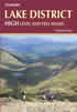 This guidebook describes 30 graded fell walks on the ridges and high peaks of the English Lake District, the UK's most popular national park. Reaching some of England's finest and highest mountain scenery, this guide leads readers to classic horseshoes and traditional ascents as well as lesser-known routes to quieter summits.
More information
Walking the Lake District Fells - Wasdale
 Part of the Walking the Lake District Fells series, this guidebook covers a wide range of routes to 25 Lakeland summits that can be climbed from the Wasdale, Eskdale and Ennerdale valleys, with highlights including Scafell Pike, Great Gable and Pillar. Suggestions for longer ridge routes are also included.
More information
