Walk 2592 - printer friendly version
Llyn Geirionydd & Llyn Bychan from Llyn Crafnant Walk
Author - Mike Bexley
Length - 9.5 miles / 15.4 km
Ascent - 1900 feet / 576 metres
Grade - moderate
Start - OS grid reference SH756618
Lat 53.138786 + Long -3.8611224
Postcode LL27 0JZ (approx. location only)
Although this Snowdonia (Eryri) walk is named after the 'water features' passed during the walk, most of the route is through sparsely planted old forests and includes the pass from Capel Curig to Crafnant. This is a quieter area of North Wales within the Snowdonia National Park and away from the tourists and popular paths. It is magnificent country. Paths and route finding are easy and the views superb.
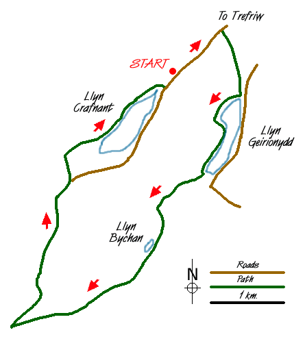
The walk starts from Crafnant Car Park (Grid ref. SH756618) with its toilet block. This car park is approached from Trefriw. If motoring from Llanrwst, turn up the very steep hill on the left immediately after Trefriw Woollen Mill. This leads to a narrow lane with passing places with the car park at the end just prior to Lyn Crafnant.
Exit the car park and turn left down the lane towards Trefriw. Ignore the first signed footpath near the car park and continue for approximately half a mile to the next signed footpath on your right (Grid ref. 762624). Go through the gate and proceed down the field to a farm gate and bridge. Do not go through this gate but turn left along the short footpath to cross right over the Afon Crafnant via the footbridge.
Ahead of you is a large mine building. On reaching the spoil heaps climb left of the building to cross over a stream at the back via a convenient plank leading to mine working caves. At their entrance, follow the path left up the bank then right at the top over a stile. The path then splits. If you feel like some exercise take the left hand path straight up the hill turning right near the top to join a level grass path that meets the other path. Both paths meet up with the road leading to the left hand side of Llyn Geirionyd (Grid ref. 766615).
Go through the gate and follow the path on the western shores of Llyn Geirionyd. There are plenty of places on the lakeside to enjoy your packed lunch as you walk south. The path leaves the lake at the house named Ty-newydd where you go over the stile and turn right up the forest road. Keep on this road until you reach the second five bar gate on the left situated on a corner. Turn left through this gate and still heading south follow the forest road gradually climbing to pass the small Llyn Bychan on your right (Grid ref. 753594).
On reaching the forest road junction turn right (this forest road is not indicated on some maps, a lower forest road is shown). Keep to the road that curves around then heads west to join a footpath. Continue in the same direction over stiles leaving the forest behind and dropping down to a concrete footbridge (Grid ref. 732581). The perfect mountain on your left is Moel Siabod whilst ahead of you is the breathtaking view up the Ogwen valley.
Do not cross over but turn right at this bridge to steadily climb up the Nant y Geuallt Pass. When you reach the top, I recommend the path up and down to the ridge on your left from where there are excellent views. The onward path now drops down to the head of Llyn Crafnant (Grid ref 740603). You can turn left passing holiday cottages and return via the left hand side of the water or alternatively go through the five bar gate ahead and walk on the road passing (or stopping at) the lakeside café. Both routes end up at the outflow of Llyn Crafnant from where you follow the road to bring you back to the car park.
Messaging & Social Media
Message Walking Britain and follow the latest news.

Mountain Weather
Stay safe on the mountains with detailed weather forecasts - for iOS devices or for Android devices.