Walk 2608 - printer friendly version
Crimpiau & Creigiau Gleision from Llyn Crafnant Walk
Author - Mike Bexley
Length - 7.5 miles / 12.2 km
Ascent - 2500 feet / 758 metres
Grade - moderate
Start - OS grid reference SH756618
Lat 53.138786 + Long -3.8611224
Postcode LL27 0JZ (approx. location only)
This is one Snowdonia (Eryri) walk you must not miss if you are in the area. However I would recommend you undertake it when the mountains are free of cloud so as not to miss the spectacular views of Moel Siabod, Tryfan and the Ogwen Valley plus the flatter plains beyond Llanrwst. Also once on the main wide ridge there are no obvious escape routes down either side of the steep flanks. Navigation is easy but the walk uses paths that are not shown on the maps. There are many steep climbs where hands serve a purpose but there is no hard scrambling or rock climbing.
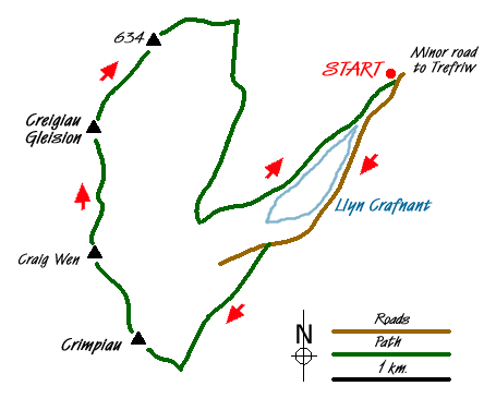
Start from the small car park (Grid ref. SH756618) that is approached up a narrow road from Trefriw near Llanrwst. After parking walk up the tarmac road with the tumbling river on your right. Continue on the road with beautiful Llyn Crafnant on your right. Across the reservoir can be seen the impressive tops of the mountains that form your return route.
The road finishes at a gate. Climb up the green bank ahead and walk towards an old gate in the wall. Then follow the clear path that bears right then swings to the left to climb the hill. This old path was once a very important trade route from Capel Curig. On reaching the top at a small col (after a few stops to enjoy the improving views) the view ahead is dominated by Moel Siabod.
At this highest point in the main path climb the narrow path on your right. The path climbs steeply to the rocks below Crimpiau then bears to the left to skirt around the mountain (an alternative route). Climb up the rocks following one of the many feint paths to the top of the minor summit of Crimpiau (Grid ref. 733 596), which despite its slowly height offers great views in either direction.
Your next climb is up to Craig Wen and it is worth taking your time at this point to study the descending path from Crimpiau and the path up this next summit. On reaching Craig Wen (Grid ref. 729 603) navigation becomes easier on well-worn paths although do remember to always keep to the high ground. In the valley on your right is Lyn Crafnant and on the left the long Llyn Cowlyd Reservoir with its dam wall.
Eventually the long ridge ends at Creigiau Gleision (Grid ref. 735 623) from where you descend right on the worn path to a fence. Go over the fence, and still descending, follow the fence that turns left to the bottom of a broad col (Grid ref. 742 624). Do not climb up the hill ahead but clamber over the right hand fence and follow the path down to the woods (Grid ref. 742 620).
Note - Many of the following paths are indicated by yellow arrows. A wide wet path descends through the woods to reach a forest road. Cross over and again descend following a path to another forest road. Turn right then left to follow the path, still descending. Take the first path on your right again through the woods. Cross over the forest road to follow a path that takes you to a narrow stream crossing. Then look out for a steep overgrown path on the left. This finishes at a wide track. Turn left on this track dropping down to the bank of Llyn Crafnant. Go through the swing gate at the end of the reservoir then left on the road back to your start.
Messaging & Social Media
Message Walking Britain and follow the latest news.

Mountain Weather
Stay safe on the mountains with detailed weather forecasts - for iOS devices or for Android devices.