Walk 2707 - printer friendly version
Tyrrau Mawr and Craig-y-llyn from Llanfihangel-y-pennant Walk
Author - Lou Johnson
Length - 9.5 miles / 15.4 km
Ascent - 2650 feet / 803 metres
Grade - moderate
Start - OS grid reference SH673095
Lat 52.666921 + Long -3.9637514
Postcode LL36 9TU (approx. location only)
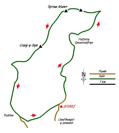
This excellent walk in the Southern sector of the Snowdonia (Eryri) National Park offers some excellent views across Barmouth and the Mawddach Estuary. The paths are quiet and see far fewer people than neighbouring Cadair Idris, which lies to the immediate east along the ridge. The main objectives of the walk are the summits of Tyrrau Mawr and Craig-y-llyn both of which are flanked by steep crags on their northern side.
Limited parking is available on the verge just before the bridge over the Afon Cadair (Grid ref. SH673095) or in the village car park at Llanfihangel-y-pennant which adds a little extra mileage to the walk. Cross the bridge over the Afon Cadair and bear right following the track signed to Cadair Idris. This climbs steadily up the valley to reach a ford just past Hafotty Gwastadfryn from where the route steepens briefly before easing for the climb up to the col east of Carnedd Lwyd. From here the views open out and you get a grand panorama looking north to the southern Rhinogs and beyond.
At the col turn left and leave the many walkers heading east to the summit of Cadair Idris. The path climbs over the rocky summit of Carnedd Llwyd to reach the first objective of the day - Tyrrau Mawr with its north facing steep crags. From here the view is excellent especially over Barmouth and the river estuary.
Having enjoyed the view, continue westwards following the fence as you first descend and then ascend onto the summit of Craig-y-llyn again with a line of north-facing crags that drop down to Llyn Cyri far below. Continue west, descending to a broad col (Grid ref. SH654114). Turn south here to locate the track that follows the right of way south into the valley. Some detective work is required to locate this path but once found it will lead you to a wall corner (Grid ref. SH656106). From here the line of the path is easier to follow using the OS map and you soon reach the valley floor and Nant-Cawr-fawr farm.
Go through the farm and continue along the lane to Bodilan Fach and a chapel. Cross the stile to left of the chapel and continue across pastures to Maes-y-llan. If you have parked in the village car park then cross the river here and continue along the lane to the village and car park. If you have parked on the verge beside the river, then stay on the path and continue to the bridge crossed at the start of the day.
Messaging & Social Media
Message Walking Britain and follow the latest news.

Mountain Weather
Stay safe on the mountains with detailed weather forecasts - for iOS devices or for Android devices.