Walk 2814 - printer friendly version
Corndon Hill from Priest Weston Walk
Author - Jake Robertson
Length - 1.5 miles / 2.4 km
Ascent - 650 feet / 197 metres
Grade - easy
Start - OS grid reference SO302977
Lat 52.572622 + Long -3.0313529
Postcode SY5 0JJ (approx. location only)
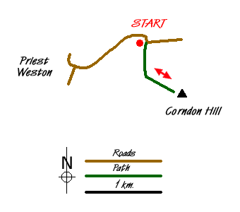
Although this is only a very short walk, it is rather excellent. Lofty Cordon Hill dominates the Marches for miles around, its distinctive bumpy shape a landmark, yet a surprisingly quiet one. Save this for a clear and warm day, the views are simply unrivalled. Park at the top of the road between Priest Weston and White Grit, where it turns sharply twice. There is small car park on the end of a track to Mitchell's Fold stone circle (Grid ref. SO302977).
Walk south along a track down the west side of the hill for a short way to the edge of a recently deforested wood (Grid ref. SO302971). Go though a gate and stile with an access sign on the left then follow the path uphill directly to the trig point, cairn and bench on the top, reached after an energetic climb. To return, simply use the outward route, ideally after a good hour on the top (Grid ref. SO305969).
At 1682ft (513 m), Corndon Hill sits just inside the English/Welsh border with Stiperstones, Long Mynd and the Clee Hills of Shropshire close by. The hill was formed by magma being thrusted though the Earth's crust then cooling, the dolerite rocks clearly visible on the east side. As far as hills go, Corndon Hill ranks in the highest order, the sense of height is tremendous with the Severn Valley being over 1300ft below and only the nearby Stiperstones is higher. The rolling grassy summit adds spaciousness to the top which looks out over quite simply one of the most beautiful and extensive views from any hilltop.
To the north the long line of Cadair Idris, the Rhinogs, Arans, Arenigs and Berwyns fill the skyline with the Clwydian Hills, Cheshire Plain and Staffordshire Moorlands slightly to the east. Past the Shropshire hills southwards lie the Malvern Hills, Black Mountains and Radnor Forest with the Elenydd and Pumlumon mountains to the west. In between is a seemingly endless patchwork of fields, woods and moors, a magical and captivating view, begging you to stay and gaze in awe.
Messaging & Social Media
Message Walking Britain and follow the latest news.

Mountain Weather
Stay safe on the mountains with detailed weather forecasts - for iOS devices or for Android devices.