Stob na Broige, Buchaille Etive Mor, Glen Coe
Highland Walk
County/Area - Highland - Fort William Lochaber
Author - Peter Smyly
Length - 6.1 miles / 9.9 km Ascent - 2500 feet / 758 metres
Time - 5 hours 30 minutes Grade - mod/hard
Maps 

| Ordnance Survey Explorer 384 | Sheet Map | 1:25k | BUY |
| Anquet OS Explorer 384 | Digital Map | 1:25k | BUY |
| Ordnance Survey Landranger 56 | Sheet Map | 1:50k | BUY |
| Anquet OS Landranger 56 | Digital Map | 1:50k | BUY |
Walk Route Description
Click image to visit gallery of 5 images.
Buachaille Etive Mor (meaning "the great Herdsman of Etive") is one of the classic mountains of the north-west highlands of Scotland, but the name does not refer to a Munro. Rather, it is a ridge of high ground to the south-east of the Glen Coe valley. The ridge includes two Munros, one at each end, as well as two tops which, while exceeding three thousand feet in height, do not qualify as Munros due to an insufficient amount of drop in height between them and their nearest neighbouring summit. This walk includes one of the two Munros, Stob na Broige.
The familiar picture postcard image of Buachaille Etive Mor presents its eastern end in the form of a giant, steep pyramid which appears to offer no easy way up. This is the impression of it when seen from the A82 road that passes through the Glen Coe valley; this however is only one end of the ridge and this walk does not include this part of the ridge.
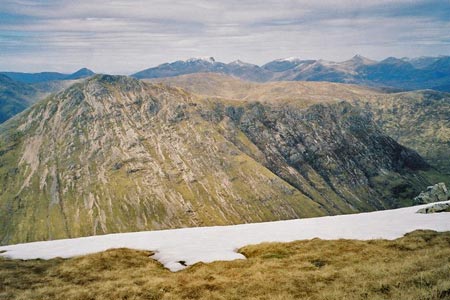
Start at the car park to the north of the Glen Coe valley to the east of Lochan na Fola and follow the Lairig Gartain valley in a south-westerly direction alongside the River Coupall for about a mile. Next it is time to gain some altitude in earnest as a fairly steep path goes up to a bealach, emerging between the minor tops of Stob na Doire on the left and Stob Coire Altruim on the right. The most difficult part of the walk now over, turn right and walk up to Stob na Broige and then the last stretch offers easy ridge walking to the Munro, Stob na Broige. On a clear day, the all-round views are magnificent with Buachaille Etive Beag arresting the attention across the glen to the north west. Further away is the Aonach Eagach across the Glen Coe valley and the Mamores range and Ben Nevis are seen to the north.
To conclude the walk, reverse the outgoing route. I was privileged to do this walk in May 2006 on a day of sunshine and near-perfect visibility as my photos show.
Other walks nearby
| Walk 3010 | Stob Dearg (Buachaille Etive Mor) from Altnafeadh | mod/hard | 4.0 miles |
| Walk 3269 | The Munros of Buachaille Etive Mor | mod/hard | 8.2 miles |
| Walk 2808 | Buachaille Etive Beag, Glen Coe | hard | 9.0 miles |
| Walk 2554 | The Lost Valley, Glen Coe | easy/mod | 4.2 miles |
| Walk 3251 | Bidean nam Bian via Stob Coire nan Lochan, Glencoe | hard | 5.0 miles |
| Walk 1496 | WHW - Day 6 - Kinlocheven to Fort William | moderate | 15.0 miles |
| Walk 3106 | Binnein Mor from Kinlochleven | hard | 10.2 miles |
| Walk 1039 | Am Bodach and Stob Coire a' Chairn | mod/hard | 9.5 miles |
| Walk 1094 | Blackwater Reservoir | moderate | 11.5 miles |
| Walk 2955 | Ridges & peaks of Bidean Nam Bian | very hard | 10.5 miles |
Recommended Books & eBooks
Walking in Torridon
 This guidebook contains 52 day walks in Torridon, a remote and much-loved area of the Scottish Highlands. Based around Shieldaig and Slioch, the routes are split into 3 sections: easy walks, long and high level walks and mountain ascents over 2000ft including 9 Munros, and 5 outline suggestions for major ridge walks.
More information
Great Mountain Days in Scotland
 Inspirational guidebook to 50 challenging routes for mountaineers, scramblers, hillwalkers and fell runners, many long enough to backpack over 2 days, especially in winter (12 to 25 miles). A mix of classic routes and unsung gems across Scotland from Galloway to the Outer Hebrides in widely differing wild landscapes. With customised OS mapping.
More information
Messaging & Social Media
Message Walking Britain and follow the latest news.

Mountain Weather
Stay safe on the mountains with detailed weather forecasts - for iOS devices or for Android devices.