Walk 2827 - printer friendly version
Rodden & Langton Herring from Abbotsbury Walk
Author - Lou Johnson
Length - 9.2 miles / 15 km
Ascent - 800 feet / 242 metres
Grade - easy/mod
Start - OS grid reference SY579852
Lat 50.6649390 + Long -2.5970420
Postcode DT3 4JL (approx. location only)
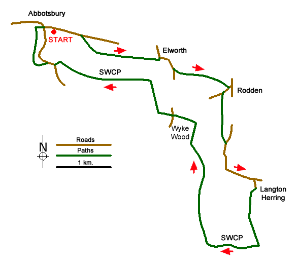
The pretty Dorset village of Abbotsbury provides a perfect starting point for this walk. There is a pay and display car park on the south side of the B3157 just east of the village centre (grid ref. SY579852). Refreshments are available in Abbotsbury and there is a pub in Langton Herring (check opening hours before starting).
After parking exit the car park and turn right along the B3157. Continue along this road for about 600 metres to reach a signed bridleway on your right (grid ref. SY583851). Follow this clear route - The Ridge Bridleway - and continue east to West Elworth which is reached in about a mile. Reaching the lane through this hamlet (grid ref. SY597847) turn right and continue along the lane for just over 300 metres. Turn left onto the continuation of the Ridge Bridleway and continue to a lane at Rodden (grid ref. SY610842).
Turn right down the lane and then take the first footpath on the left (grid ref. SY609841). This path leads across pastures in a shallow valley to a lane (grid ref. SY609832). Turn right down the lane and continue into the centre of Langton Herring. Turn right down Shop Lane, passing the parish church on your right, and locate the footpath (an enclosed track) that heads south towards the sea. Reaching the northern edge of Under Edge Planation bear left and stay on the track which runs alongside the eastern edge of this woodland.
Reaching the shores of West Fleet (grid ref. SY615813), turn right onto the South West Coast Path. To your left across the lagoon is Chesil Beach. The South West Coast Path is well signed and this is followed all the way back to Abbotsbury. Despite its name this long distance footpath does not follow the coast on this section turning inland around the Perimeter of Wkye Wood before climbing onto a ridge running west between Merry Hill and Linton Hill. This section offers some fine views south to Chesil Beach and the English Channel.
Reaching a lane (grid ref. SY579846) close to Horsepool Farm, bear right and then in a short distance leave the lane and continue following the South West Coast Path as it passes beneath the eastern slopes of Chapel Hill on your left. If you have enough energy, then the short climb up to St Catherine's Chapel is worth the effort. Whatever your choice, continue north the short distance back to Abbotsbury and some well-earned refreshment. Also remember to allow time to explore the village which is full of interest.
Messaging & Social Media
Message Walking Britain and follow the latest news.

Mountain Weather
Stay safe on the mountains with detailed weather forecasts - for iOS devices or for Android devices.