Walk 2835 - printer friendly version
Arundel to Amberley Walk
Author - Lou Johnson
Length - 6.2 miles / 10.1 km
Ascent - 250 feet / 76 metres
Grade - easy
Start - OS grid reference TQ024064
Lat 50.8480680 + Long -0.5468038
Postcode BN18 9PH (approx. location only)
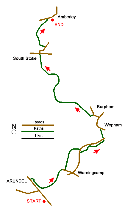
This linear West Sussex walk in the South Downs explores the River Arun from Arundel upstream to Amberley. The start is Arundel railway station (grid ref. TQ024064) where regular trains connect with the end of the walk at Amberley. Parking is available at both stations although my preference would be to park at Amberley and take the train to Arundel to start the walk.
Leave Arundel station and walk towards the town centre along the A27.At the roundabout continue straight ahead towards the town centre. Reaching the bridge over the River Arun, take the footpath on the right before crossing the bridge. This path leads along the river bank following the Monarch's Way long distance footpath. After 800 metres bear right away from the river, cross the railway. Immediately after crossing the railway turn left alongside the railway After 500 metres the path bears right away from railway, crosses a footbridge and reaches a road (grid ref. TQ035078). Turn right along the road and almost immediately turn left on to a signed path into woodland. After 800 metres from the road you will reach a cross path (grid ref. TQ041081). Turn left down to the road.
Cross the road and take the footpath opposite. This path leads to a road at the western end of Wepham Village (grid ref. TQ041085). Turn left and follow the road to reach a T-junction in the village of Burpham (grid ref. TQ040088). Continue straight ahead passing the George Inn on your left. Continue straight ahead down a no-through road to regain the river ban path at grid ref. TQ037088). Turn north along the river (river to your left). After 2 km alongside the river, the path turns north away from the river, crosses the Gurkha footbridge and reaches the road at North Stoke (grid ref. TQ023107). Turn left for a short distance and the right down Stoke Road (opposite the telephone box).
Follow Stoke Road as it bends to the right and then right to reach a footpath sign on your left, just past a red brick house on your right. Follow this path down to the banks of the River Arun (grid ref. TQ021113). Turn right (upstream) and continue along the path, which leads easily to reach the Arun river bridge at Amberley. Turn right along the road to reach Amberley railway station in 200 metres.
Messaging & Social Media
Message Walking Britain and follow the latest news.

Mountain Weather
Stay safe on the mountains with detailed weather forecasts - for iOS devices or for Android devices.