Walk 2902 - printer friendly version
Creigiau Gleision & Llyn Cowlyd from Capel Curig Walk
Author - Lou Johnson
Length - 9.5 miles / 15.4 km
Ascent - 2400 feet / 727 metres
Grade - moderate
Start - OS grid reference SH720582
Lat 53.105591 + Long -3.9134693
Postcode LL24 0EN (approx. location only)
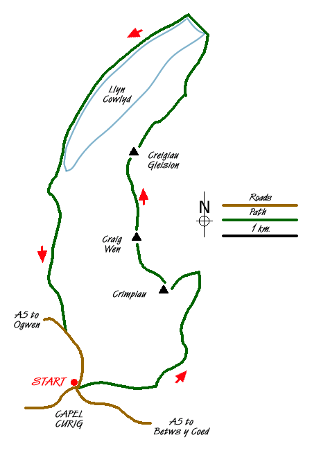
This Snowdonia (Eryri) walk explores some less frequented summits to the north of Capel Curig. The route was researched after a wet spell and there were many places on the walk where watery paths and soggy peat were a nuisance. It is therefore recommended that you do this walk after a dry spell although with Capel Curig one of the wettest places in Wales, this may be easier said than done. However even with wet ground the walk is classic offering some unusual views of familiar peaks. There are cafés, shops and toilets in Capel Curig.
The start is the village of Capel Curig. The pay and display car park (grid ref. SH720582) is located in the centre of the village behind Joe Brown's Outdoor Shop. Exit the car park and cross the A5 to follow the signed path. This takes you through a small valley with Clogwyn Mawr to your left and the Pinnacle to your right. The path descends a little and then climbs again to reach a junction of paths (Grid ref. SH731581). Take the left hand fork here. The path climbs steadily to a col to the east of Crimpiau (Grid ref. SH738597). From here there are excellent views down Llyn Crafnant over 500 feet below.
Leave the main path and take the path cutting back and uphill on your left. Although indistinct in places, this path at first follows the wall and then climbs to the summit of Crimpiau (Grid ref. SH733595) from where you will have a reasonably clear view of the route ahead with a section of white quartzite between Creigiau Gleision's two summits that will be passed later in the walk.
Descend North West from Crimpiau taking the easiest line through the rocky landscape. The first objective is the col below Craig Wen. From here the route follows the ridge north with Craig Wen's summit offering an ideal place to take a break. The path meanders through the rocky terrain with a few opportunities for simple scrambling if you wish. The climb is punctuated with short sections of descent with some boggy areas in the dips. However the route is never in doubt and you soon reach the highest summit of Creigiau Gleision (678m).
To continue follow the ridge north passing the conspicuous white quartzite mentioned earlier. You descend steadily to reach a col before starting to climb again to the north summit (634m). All along this ridge you have good views of Pen Llithrig y Wrach to your right as well as longer views to the Ogwen Valley and other parts of Snowdonia (Eryri).
Descend from the north summit to a fence (Grid ref. SH738624). Cross the fence and turn right to follow the boundary as it heads northeast. At the first fence junction (Grid ref. SH741624) turn due north crossing rough ground. Stay on this bearing until you meet a cross path going northwest down to the dam at the head of Llyn Cowlyd.
Cross the dam to the other side of the valley. On reaching the far bank turn left along the first path and follow this as it shadows the bank of Llyn Cowlyd eventually joining a wider path at grid ref. SH728629). This is then followed all the way along the lake to Bwlch Cowlyd (Grid ref. SH7166609) and a junction of paths. Turn left and cross the leat and start the long gentle descent to the A5 a kilometre north of Capel Curig. Turn south onto the main road and return to the start.
Messaging & Social Media
Message Walking Britain and follow the latest news.

Mountain Weather
Stay safe on the mountains with detailed weather forecasts - for iOS devices or for Android devices.