Walk 2941 - printer friendly version
Out Wood & Beacon Hill from Loughborough Walk
Author - Jon Ivins
Length - 6.8 miles / 11.1 km
Ascent - 650 feet / 197 metres
Grade - easy/mod
Start - OS grid reference SK516176
Lat 52.7535580 + Long -1.2369193
Postcode LE11 3TN (approx. location only)
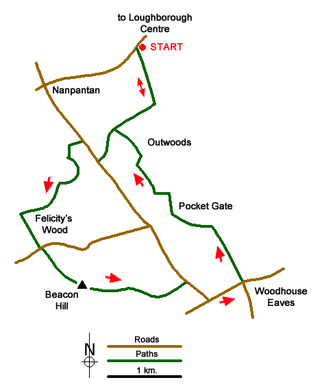
This Leicestershire walk starts from the outskirts of Loughborough and visits the county's highest point The Beacon. The summit offers fine views over a large area of Leicestershire and the East Midlands. The route takes you through The Out Woods with careful navigation and a relevant map necessary to complete the walk. For those requiring refreshments there is a convenient pub in Woodhouse Eaves village. Part of the walk crosses a narrow brook via steppingstones, please take this into account if it has been very rainy.
Free car parking is available in Watermead Lane adjacent to the start of the walk on Nanpantan Road to the southwest of Loughborough centre (SK516176). After parking take the signed track running south and parallel to Watermead Lane (out past the club house and sports fields). Continue past the sports ground on your left. After 700 metres, before the sign saying private farming land turn right leave the track (grid ref. SK518170) and follow the path/track up into Out Woods. Once in the woods take the path ahead of you to reach Woodhouse Lane (grid ref. SK511163). Turn right along the road and after 200 metres turn left right through a wooden kissing gate along a path clearly signed 'permissive path'. As you come out of the woods, keep the fencing/wall to your right go up, follow through the woods, then in the woods take a left up – it's a bit of a scramble onto a ridge (at the top there are rocks coming out of the ground virtually upright). Follow the path through the woods where the three paths meet turn right and follow the map, you then come out at a brook with a wooden bridge over it. Walk across the field with the brook on your left. Take a right and the brook is now on your left again. Follow the path, where the gate is you can come out into the field but do not walk - up the field, keep the brook to your left. Walk through the field, if not overgrown you can keep to the narrow path. You then take a sharp left through the gate and over the stepping stones. Follow this rather sinuous path through Felicity's Wood and over a ladder stile into Dean's Lane (grid ref. SK504152).
Turn left and almost immediately right onto a path signed as 'Beacon Hill Country Park - North Gate'. Follow the path initially through trees to reach open land with Beacon Hill now in sight. Follow the wide path then cut through left on to the summit and enjoy the view. (If not too windy lovely to sit and have lunch on the edges or the bench). From the summit descend east on a clear path soon a joining a clear track that leads to Beacon Hill Lower Car park (grid ref. SK521148). Just before reaching the road take the track on the right (to the left of a wooden bench). Continue a short way along this track soon bearing left onto a narrower path that leads parallel to Breakback Road to reach a T-junction with Woodhouse Road (grid ref. SK524146).
Turn left into Woodhouse Eaves and walk to reach the Old Bull's Head pub on the right. Just opposite the pub, turn left down Brook Road along a signed footpath to Loughborough. Continue along this lane for 1.5 km to reach a junction of tracks (grid ref. SK520156) just south west of Pocket Gate Farm. Continue along Brook Road and locate the path on the right a short way past the junction of tracks (approx. grid ref. SK519155). Now comes a tricky section of navigation. Follow the path through the trees to join a clearer path at grid ref. SK519156 heading north. This path is marked with orange flashes and leads north through Out Woods. Continue on this path north for 1.4 km following the orange flashes to reach a T-junction with the track used for the first part of the walk at grid ref. SK513167). Turn right and retrace your steps back to the start.
Messaging & Social Media
Message Walking Britain and follow the latest news.

Mountain Weather
Stay safe on the mountains with detailed weather forecasts - for iOS devices or for Android devices.