Walk 3051 - printer friendly version
Yr Elen from Gerlan Walk
Author - Lou Johnson
Length - 6.5 miles / 10.6 km
Ascent - 2820 feet / 855 metres
Grade - hard
Start - OS grid reference SH637660
Lat 53.173603 + Long -4.040688
Postcode LL57 3UB (approx. location only)
Topping 3000 feet, Yr Elen is the twelfth highest peak in Wales yet it is rarely features as the objective of a walk usually being included as part of a longer round over Carnedd Llewelyn to which it is connected by a ridge. It is worth warning that this walk covers some pathless territory, includes an airy ridge with some scrambling and could be impossible to complete if the rivers are in spate. It is also worth noting that it would be difficult to complete the walk with dry feet unless you have decent gaiters. That said it is a great route and apart from the summit of Yr Elen you are likely to have the mountains to yourself. An alternative route to the summit is featured in walk 3052.
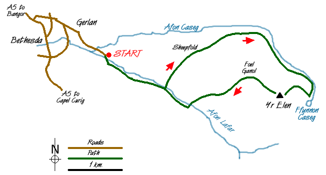
The start of this Snowdonia (Eryri) walk is a small lay-by (Grid ref. SH637660) at the end of the lane running south-east from the village of Gerlan, which is located to the east above Bethesda. Should this space be full then further limited parking can be found further back to Gerlan adding about a mile to the distance. After parking cross the bridge over the Afon Lafar to take the signed right of way heading past the water works and along its southern bank towards the Carneddau.
You climb steadily with the view ahead including the northern flanks of the Carneddau with Yr Elen clearly in view (except on the day this walk was researched!) when only the lower slopes were below the cloud. You reach 'open country' (Grid ref. 648654) where you continue on the path to reach an isolated cast-iron railing. Descend left to cross the Afon Lafar, which, if in spate will be difficult, to gain the northern bank. Head just east of north across boggy ground and grass aiming for the sheepfold (Grid ref. 656661), which remains unseen until you have crested the north-western ridge of Yr Elen.
From the sheepfold contour east trying not to lose height to reach the south bank of the Afon Caseg. The going is pathless and you will encounter some more boggy areas so just grit your teeth and keep going! Having reached the Afon Caseg you will be able to use sheep trods and make better progress upstream. The valley narrows as you gain height and as the route turns south you will reach the small tarn of Ffynnon Caseg, which is beautifully located with the crags of Yr Elen soaring upwards above you.
The onward route needs care and should only be completed if you can see where you are going. From the small ruin on the northern shore of Ffynnon Caseg head north-north-west up the ill-defined ridge towards the crags above. The going is steep over grass and stones. You are probably unlikely to locate the feint path so just take care and if in doubt trend north to reach the foot of rockier terrain clearly in view above. Here you should be able to find the narrow path that leads through the crags with some scrambling up the east ridge of Yr Elen to reach the summit plateau.
After enjoying the view the descent leads north from the cairn, dropping steeply through rocky terrain onto the north-western ridge. After the initial descent the going gets easier and keeping south of Foel Ganol you descend over grass to cross boggy ground to reach Afon Lafar. Cross where convenient and head back down the path to the start.
Messaging & Social Media
Message Walking Britain and follow the latest news.

Mountain Weather
Stay safe on the mountains with detailed weather forecasts - for iOS devices or for Android devices.