Walk 3057 - printer friendly version
Moel Eilio from Llanberis Walk
Author - Lou Johnson
Length - 7.0 miles / 11.4 km
Ascent - 2300 feet / 697 metres
Grade - moderate
Start - OS grid reference SH567595
Lat 53.113376 + Long -4.1424301
Postcode LL55 4SR (approx. location only)
This quiet, rewarding Snowdonia (Eryri) walk from Llanberis takes in one of the lesser known summits of the Snowdon range. Rising to 726 metres, the summit Of Meol eilio offers good views of a wide range of mountains in the northwestern sector of the Snowdonia National Park.
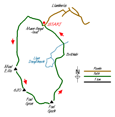
The distance and height gain is quoted from Maen-llwyd-isaf (Grid ref. SH567595). This derelict farmstead has limited parking nearby and can be reached up a gated road from the centre of Llanberis, leaving the main street by Fford Capel which leads to the Youth Hostel and then turning right by the chapel. For those without transport, the start can be gained by walking the same route and taking a more direct return at the end of the walk.
After parking continue through the gate to the right of the farmstead and walk up the track, which heads north before turning west. Reaching an open area after passing through a gate look out for the path that goes left climbing steadily over grass. Initially southwest, the path improves and turns south to follow a derelict wall. The ascent is steady and you are joined by another path coming in from your left. One final pull and you are on the summit. The views are excellent and you may be hard pressed to name all the summits that can be seen.
Descend south on a clear path over an unnamed summit (629 metres), Foel Gron (593 m.) to reach Foel Goch (605 m.). The going is easy over grass. Despite the undulations along the ridge, with Snowdon ahead you make steady progress. To your left there are crags with Llyn Dwythwch far below.
From Foel Goch the route heads just east of north descending down a broad ridge. There is a path of sorts on the initial descent although it fades when you reach a flatter area of marshy ground. The best idea is to keep right over this section making sure you do not descend into the valley of Maesgwm. Ahead you will see a ladder stile (Approx. grid ref. SH 575572) and this is the next objective. Cross this and head to another stile which can be seen in good visibility roughly north of the first stile. Staying on this heading you will descend over rough grass and rock to reach another stile over a wall (Approve grid ref. SH 574579). From here a more distinct path emerges and this lead to a track. Turn right along the track to reach another track at Brithdir. Turn left and continue along the track to reach a house (Grid ref. 573591) where you join a bridleway that leads back to the start.
Messaging & Social Media
Message Walking Britain and follow the latest news.

Mountain Weather
Stay safe on the mountains with detailed weather forecasts - for iOS devices or for Android devices.