Canal from Birmingham to Sandwell
West Midlands Walk
County/Area - West Midlands
Author - Lou Johnson
Length - 8.0 miles / 13 km
Ascent - nominal or unknown
Time - 4 hours 0 minutes Grade - moderate
Walk Route Description
Click image to visit gallery of 12 images.
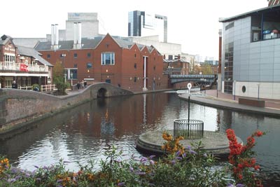
The canal system in the Birmingham is extensive with more miles of canal than found in Venice! Stretching out into the surrounding towns and cities their construction helped provide the important transport infrastructure that was needed by the Industrial Revolution. Today much of the network remains intact although it sees very little of the freight that it was designed to service. Today the traffic is almost totally for leisure purposes. This walk explores the Birmingham Canal Navigations route from Digbeth Basin to Bromford Lane Bridge (Sandwell). The walk follows the "new main line" but also investigates sections of the "old main line" in the Galton Valley area.
This linear route starts from Birmingham New Street station and ends at Sandwell & Dudley station. These are linked by a frequent rail service with 3 trains most hours. Exit the main concourse of New Street Station and follow the clear signage to Moor Street Station. From Moor Street station, continue down Moor Street, turn left into Park Street, right into Bordesley Street, left into New Bartholomew Street, and then right into Fazeley Street to reach the canal.
Join the canal towpath with the canal on your left. Cross the bridge ahead and, ignoring the canal going right, continue under the railway bridge ahead. The route continues past Ashted Locks and through the Aston Science Park to reach Aston Junction where you cross the footbridge and bear left to follow the canal under the Aston Expressway.
The walk passes under Barker Bridge to reach the first of 13 locks that make up the Farmer's Bridge flight that terminated by Cambrian Wharf. Ignore all bridges across the canal and continue with the canal on your left past the National Indoor Arena at Deepcutting Junction to reach St Vincent Bridge. It is important that you keep the canal on your left to walk along the lengthy straight section ahead to reach Winson Green Junction.
Cross the footbridge and with the canal still on your left continue northwest passing under the railway and Rabone Lane Bridge to arrive at Smethwick Junction where you cross the footbridge and then follow the right hand canal - the "old main line". With the canal now on your right continue past Smethwick Locks with the restored toll house adjacent.
If time permits a short detour to the left across Telford's viaduct over the "new main line" is worthwhile before continuing along the towpath to pass the restored pumping station. Ahead is Galton Bridge, once the longest single span bridge in the world, although the view is quickly lost as you enter summit tunnel.
Exiting the tunnel the canal passes between the supporting columns of the M5 motorway to reach Spon Lane Junction. Here you bear left to follow the "old main line" for a short distance to the point where it crosses the "new main line" far below. Descend the steps to the "new" towpath and continue with the canal on your left under the motorway to reach Bromford Junction.
Go left across the footbridge and continue along the "new" with the canal now on your right to reach Bromford Lane Bridge. Ascend to street level and turn left with Sandwell & Dudley station a short way along Bromford Road. Looking back at the route it is worth remembering that no mechanical means were used in the construction and that after leaving the top lock of the Farmer's Bridge flight the "new main line" has no locks whatsoever - a remarkable feat considering the surrounding terrain.
Note - detailed photographic coverage of the Digbeth to NIA section can be found in walk 2204
Maps 

| Ordnance Survey Explorer 219 | Sheet Map | 1:25k | BUY |
| Anquet OS Explorer 219 | Digital Map | 1:25k | BUY |
| Ordnance Survey Explorer 220 | Sheet Map | 1:25k | BUY |
| Anquet OS Explorer 220 | Digital Map | 1:25k | BUY |
| Ordnance Survey Digital Map Subscription | |||
| Latest Ordnance Survey Discounts | |||
Other walks nearby
| Walk 2202 | Farmer's Bridge Locks & Centenary Sq, Birmingham | easy | 2.0 miles |
| Walk 2203 | Gas Street Basin & The Bull Ring, Birmingham | easy | 2.5 miles |
| Walk 2204 | Aston Junction & Millennium Point, Birmingham | easy | 3.5 miles |
| Walk 2209 | Brindley Place & the Jewellery Quarter, Birmingham | easy | 2.5 miles |
| Walk 1501 | Lickey Hills, Barnt Green and the Bittell Reservoirs | easy | 4.5 miles |
| Walk 2716 | Walton & Clent Hills from Nimmings Wood | easy | 3.5 miles |
| Walk 2667 | Barston Circular | easy | 4.3 miles |
| Walk 3683 | Hockley Heath and Packwood Circular | easy | 4.1 miles |
| Walk 3711 | Heronfield & Temple Balsall Circular | easy/mod | 7.2 miles |
| Walk 1614 | Meriden & Berkswell Circular | easy/mod | 8.0 miles |
