 Walking Britain
Edge Hill, Hornton & Upton House Circular
Warwickshire Walk
County/Area - Warwickshire & Oxfordshire
Author - Peter Schofield
Length - 6.5 miles / 10.6 km Ascent - 620 feet / 188 metres
Time - 3 hours 30 minutes Grade - easy/mod
Walk Route Description
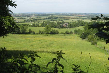
Click image to visit gallery of 6 images.
This walk explores the quintessential English countryside on the borders of Warwickshire and Oxfordshire. Visiting ancient woodland overlooking the site of one of one of England's bloodiest battles together with two charming villages, it ends at a fine country house with an outstanding art collection. Please note that the section of the walk through the woods to Ratly needs careful navigation. The same applies to finding the path to Ratly. Do take a 1:25000 OS map to help your route finding.
The walk starts at the car park of Upton House (grid ref. SP370460) on the A422 approximately seven miles NW of Banbury. Cross the stile at the south end of the car park and follow the path to a gate overlooking Home Farm. Continue ahead to a wall and follow the path to the A422 at a junction with a minor road. Go straight ahead along the A422 for 300m and as it starts to descend, turn right on to a wooded path opposite a house.
This path waymarked as both the Centenary and Macmillan Ways follows the escarpment of Edge Hill through ancient woodland, offering occasional views over the plain below where the first major battle of the English Civil War, the Battle of Edgehill took place in 1642. Continue through the woods to a junction at the foot of some steps (grid ref. SP377478). Go right up the steps to reach a road at the junction with the lane to Ratley.
Cross over and walk down Old Road to the village where after 400m the road forks. Take the right fork descending past several attractive sandstone houses to arrive at the unusually named church of St.Peter ad Vincula which dates from the 14thC. A few yards further on the right, the 11thC Rose and Crown offers a welcome refreshment halt. It is allegedly haunted by the ghost of a roundhead from the Battle of Edgehill!
Continue along the lane past the pub and after 100m, go over a stile to the right and descend diagonally across the field to a gate. The route continues across fields to a stream forming the boundary of Oxfordshire & Warwickshire. Cross the stream as the path gently rises before entering a copse through a gate to the left. Continue climbing as the route levels out at Poplars Farm and follows the farm access track to a road opposite the junction to Hornton.
Keep straight on into Hornton which is another typical English village of beautiful sandstone cottages. As the road turns left opposite a large weeping willow, go right past a children's playground and the Dun Cow pub which is only open in daytime at weekends. At the end of the lane, cross a stile and where the path forks after 100m, drop down to a footbridge over a stream. Cross the bridge and turn left as the path gently climbs across several stiles to arrive at a minor road (grid ref. SP380458).
Go left and follow the road to its junction with the A422. Turn right along the A422 for 600m to arrive back at the start of the walk. Just before reaching the car park, take a look left down the long driveway to the magnificent Upton House which is owned by the National Trust. The house was built in 1695 and now houses an outstanding collection of art including works by Canaletto, El Greco and Hogarth. It's open to the public for much of the year and well worth a visit.
Public transport is rare in the area although Ratley is served by the infrequent weekday 269 bus between Banbury and Stratford on Avon which might provide an option for those without their own transport.
Maps 
| Ordnance Survey Explorer 206 | Sheet Map | 1:25k | BUY |
| Get Ordnance Survey Digital Map Subscription | |||
| Latest Ordnance Survey Discounts | |||
Other walks nearby
| Walk 2125 | Edge Hill & Ratley from Radway | easy/mod | 5.4 miles |
| Walk 3145 | Middle Tysoe & Compton Wynyates Circular | easy/mod | 6.2 miles |
| Walk 2984 | Edge Hill from Warmington | easy/mod | 6.3 miles |
| Walk 1971 | Gallow Hill, Epwell & Swalcliffe | easy/mod | 7.8 miles |
| Walk 1981 | Epwell from Sibford Gower Circular | easy/mod | 5.6 miles |
Start Point Details
Ordnance Survey Grid Ref SP370460
Latitude 52.111094 Longitude -1.4611286
Postcode OX15 6HL
what3words start unafraid.receiving.tiger
Walk description may contain detailed information on the start point for this walk.
Further Information
Accommodation
Find Accommodation nearby by using the regional accommodation lists
Go to regional accommodation lists
Self Catering & Cottage Holidays
Properties throughout the UK & Europe
Messaging & Social Media
Message Walking Britain and follow the latest news.


Mountain Weather
Stay safe on the mountains with detailed weather forecasts - for iOS devices.