Walk 3237 - printer friendly version
Bowerchalke & the Ox Drove Walk
Author - Lou Johnson
Length - 8.0 miles / 13 km
Ascent - 700 feet / 212 metres
Grade - easy/mod
Start - OS grid reference SU040253
Lat 51.0270540 + Long -1.9443389
Postcode SP5 5DW (approx. location only)
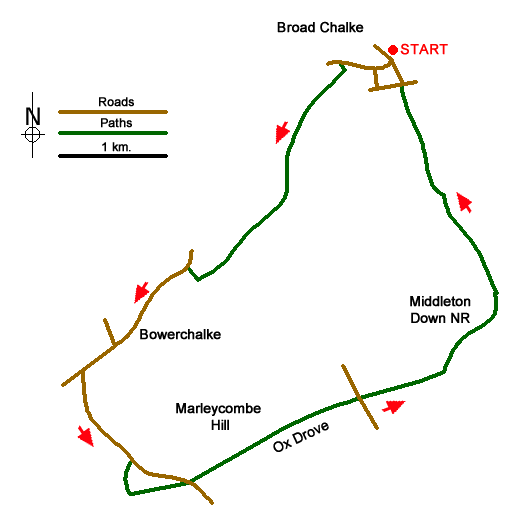
The Wiltshire countryside with rolling hills and wide views is seen by many as the typical English Landscape. This walk starts from the village of Broad Chalke in the River Ebble valley where limited on street parking is available near the parish church (grid ref. SU040253). However please park with consideration for residents and businesses. An alternative parking area is located at the western end of Bowerchalke village (grid ref. SU013225) - see paragraph 3.
After parking walk west along South Street towards Bowerchalke. After 400 metres from the church, turn left onto a signed bridleway. Almost immediately turn right onto a grassy track heading roughly southwest. This soon becomes a gravel track and leads on passing Field Barn Farm on your left (grid ref. SU032241). At a cross track continue straight ahead to reach Knowle Farm on the outskirts of Bowerchalke village. Continue through the farmyard to reach a road, Church Street (grid ref. SU023235).
Turn left along Church Street and follow it through Bowerchalke passing the parish church on your left. You can also follow a footpath that runs parallel to Church Street on the south side of the houses. This loop by passes the village centre and avoids the road. Nearing the end of the village, ignore the road on the right to Ebbesbourne and keep straight ahead towards Woodyates. At the next junction turn left, signed Woodyates (grid ref. SU013225). The alternative parking is just on this junction.
Continue along this lane through the hamlet of Misselfore climbing gently into the dry valley of Cross Bottom. Walk past the 30 speed limit signs and continue to the end of the hedge on right side of the road (grid ref. SU016219).
Clamber over the fence at some wooden rails a short way along and continue parallel to the road on a clear footpath. After 200 metres or so the path joins a track by a metal gate and shed and veers away from the road up a shallow valley. The path is indistinct in places but goes through a gap in a hedge and with careful navigation leads up to a gate and a track known as the Ox Drove (grid ref. SU018214).
Turn left along the Ox Drove, which will be followed for just under 3 kilometres. The track soon crosses the lane to Woodyates (grid ref. SU023216). Keep straight ahead ignoring tracks leading left and continue on the main track past woodland on your right to reach another lane (grid ref. SU038223). Cross the lane and with Hut Farmhouse on your left continue straight ahead to reach Hut and Lodge Farm on your right. Ignore the first track on your left just past the farm and take the second track on the left (grid ref. SU045226) heading northeast towards a small wood. After 200 metres turn right onto a footpath across a large field through the Middleton Down Nature Reserve.
This path leads to a track (grid ref. SU050223). Join the track and walk north to gently descend through Church Bottom to reach Howgare Road (grid ref. SU042251). Turn left and immediately right into the Causeway. This leads you back to the church and the start of the walk.
Messaging & Social Media
Message Walking Britain and follow the latest news.

Mountain Weather
Stay safe on the mountains with detailed weather forecasts - for iOS devices or for Android devices.