Walk 3269 - printer friendly version
The Munros of Buachaille Etive Mor Walk
Author - Lou Johnson
Length - 8.2 miles / 13.3 km
Ascent - 3740 feet / 1133 metres
Grade - mod/hard
Start - OS grid reference NN221563
Lat 56.6645400 + Long -4.9044500
Postcode PH49 4HY (approx. location only)
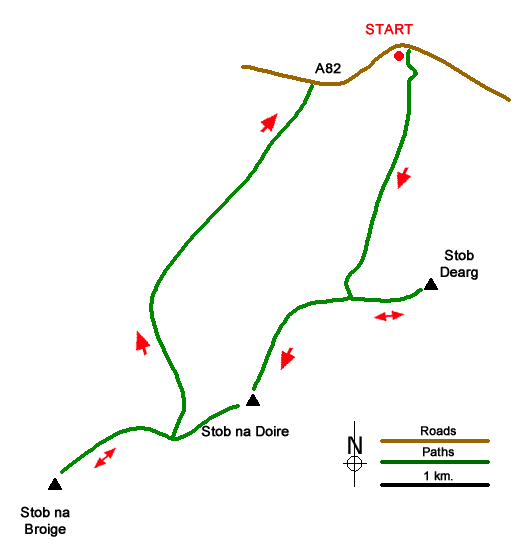
This walk from the head of Glencoe includes the two Munros on Buachaille Etive Mor, Stob Dearg and Stob na Broige. This hill lies close to the A82 near the head of Glencoe and its pyramid-like aspect is seen by many each year. Hidden from view, the hill's four-kilometre ridge contains two Munros plus two subsidiary summits. The route follows good paths and despite the steep approach to the ridge the walk offers no further difficulties.
The start is Altnafeadh (Grid ref. NN221563) where parking is available in parking areas on both sides of the A82. After parking head south along the track that leads across a bridge over the River Coupall towards the white cottage of Lagangarbh. Two hundred metres beyond the cottage the path forks. Keep right here and start to climb steadily soon crossing the Allt Coire na Tulaich. The path stays on the west side of the stream as the gradient steepens with the crags of Stob Dearg to your left.
Continuing upwards into dramatic Coire na Tulaich the path steepens with the coire wall ahead. However, you are faced with no technical difficulties with the ascent easing to reach a col (Grid ref. NN 216542). Turn left and follow the well-trodden path to the summit of Stob Dearg (1022 m.), the first Munro of the route. Take time to enjoy the view taking particular note of the onward route along the ridge to Stob na Doire and beyond to Stob na Broige.
Retrace your steps down to the col (NN216542) and continue ahead on an undulating path that follows the ridge before climbing steadily onto Stob na Doire's summit (1011 m.). Despite its height, Stob na Doire is not a Munro. A steepish descent leads down to the head of Coire Altruim (grid ref. NN201529) from where you will later descend to complete the route.
Continue ahead to cross Stob Coire Altruim with a short descent before the steady ascent along a narrowing ridge to reach Stob na Broige (956 m.). Enjoy the view which extends south-west to Loch Etive. To continue retrace your steps to the col at the head of Coire Altruim and turn left down the steep path which descends on the west side of Allt Coire Altruim to join the Lairig Gartain path (grid ref. NN199542). Follow this path down the valley to reach the A82. Turn right and return to the start.
Messaging & Social Media
Message Walking Britain and follow the latest news.

Mountain Weather
Stay safe on the mountains with detailed weather forecasts - for iOS devices or for Android devices.