Walk 3289 - printer friendly version
Loch Lundie from Invergarry Walk
Author - Lou Johnson
Length - 6.5 miles / 10.6 km
Ascent - 700 feet / 212 metres
Grade - easy/mod
Start - OS grid reference NH296011
Lat 57.0693100 + Long -4.8122724
Postcode PH35 4HG (approx. location only)
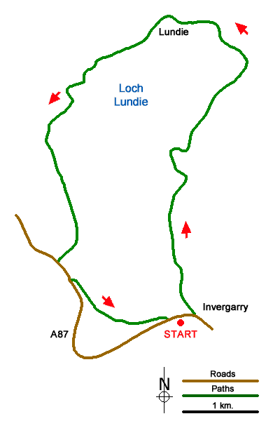
This walk around Loch Lundie, which lies above Invergarry offers mostly easy walking on tracks and paths. The route passes through mature woodland, skirts the loch, and passes through the abandoned settlement of Lundie. The area covered by the walk offers excellent scenery in a tranquil and quiet setting amongst low hills.
The start is the car park adjacent to the Invergarry Village Hall and Cultural Centre (grid ref. NH296011) on the south side of the A87 a short distance west of the village. After parking take the path by the Village Hall leading up to the A87. Cross the road with care and turn right. After a short distance turn left between white cottages to join a track. Go through a gate and follow the rising track up through woodland with Aldernaig Burn on your right. Reaching a junction, bear right and continue up to the shores of Loch Lundie.
Follow the track as it skirts the loch passing a small boat house hidden in the trees on the left. Reaching the head of the loch, turn left at a T-junction. Continue pass the remains of the settlement at Lundie. Just past Ludie the track forks. Take the narrower left-hand track. Ford a burn and continue along a less obvious and wetter path to a fence (grid ref. NH287040). Cross the stile and climb to the highest point along the route Soon after the path follows a clearer track that leads down to the edge of woodland. The track follows the edge of the woodland to reach a fork. Bear left here and continue into the trees to descend to a gate and the A87.
Turn left along the A87 where there is a narrow grass verge. Continue to a road junction. Turn left signed to Faichem. The lane rises between trees and soon levels offering a view to your right across distant hills. Stay ahead on the lane as it descends to the A87. Cross the road with care and turn left. A short walk leads you to the path from the village hall and the starting point.
Messaging & Social Media
Message Walking Britain and follow the latest news.

Mountain Weather
Stay safe on the mountains with detailed weather forecasts - for iOS devices or for Android devices.