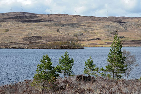
Loch Lundie from Invergarry
Highland Walk
County/Area - Highland - Central Highland
Author - Lou Johnson
Length - 6.5 miles / 10.6 km Ascent - 700 feet / 212 metres
Time - 4 hours 0 minutes Grade - easy/mod
Walk Route Description
Click image to see photo description.
This walk around Loch Lundie, which lies above Invergarry offers mostly easy walking on tracks and paths. The route passes through mature woodland, skirts the loch, and passes through the abandoned settlement of Lundie. The area covered by the walk offers excellent scenery in a tranquil and quiet setting amongst low hills.
The start is the car park adjacent to the Invergarry Village Hall and Cultural Centre (grid ref. NH296011) on the south side of the A87 a short distance west of the village. After parking take the path by the Village Hall leading up to the A87. Cross the road with care and turn right. After a short distance turn left between white cottages to join a track. Go through a gate and follow the rising track up through woodland with Aldernaig Burn on your right. Reaching a junction, bear right and continue up to the shores of Loch Lundie.
Follow the track as it skirts the loch passing a small boat house hidden in the trees on the left. Reaching the head of the loch, turn left at a T-junction. Continue pass the remains of the settlement at Lundie. Just past Ludie the track forks. Take the narrower left-hand track. Ford a burn and continue along a less obvious and wetter path to a fence (grid ref. NH287040). Cross the stile and climb to the highest point along the route Soon after the path follows a clearer track that leads down to the edge of woodland. The track follows the edge of the woodland to reach a fork. Bear left here and continue into the trees to descend to a gate and the A87.
Turn left along the A87 where there is a narrow grass verge. Continue to a road junction. Turn left signed to Faichem. The lane rises between trees and soon levels offering a view to your right across distant hills. Stay ahead on the lane as it descends to the A87. Cross the road with care and turn left. A short walk leads you to the path from the village hall and the starting point.
Maps 

| Ordnance Survey Explorer 400 | Sheet Map | 1:25k | BUY |
| Anquet OS Explorer 400 | Digital Map | 1:25k | BUY |
| Ordnance Survey Digital Map Subscription | |||
| Latest Ordnance Survey Discounts | |||
Other walks nearby
| Walk 3275 | Ben Tee & Kilfinnan Falls from Laggan | mod/hard | 7.5 miles |
| Walk 2166 | Laggan Locks Circular | easy | 4.0 miles |
| Walk 2824 | Arkaig Hills Circular | moderate | 8.8 miles |
| Walk 1781 | Loch Affric Circular | moderate | 11.0 miles |
| Walk 1789 | Mam Sodhail & Carn Eighe | hard | 14.4 miles |
| Walk 2513 | Five day Knoydart exploration | very hard | 91.4 miles |
| Walk 3255 | Coire Ardair | moderate | 7.5 miles |
| Walk 2918 | Aonach Mor and Aonach Beag - two of the "Lochaber giants" | mod/hard | 9.0 miles |
| Walk 3066 | Carn Mor Dearg (via Allt a' Mhuilinn trail) | mod/hard | 8.7 miles |
| Walk 3083 | Five Sisters Ridge, North Glen Shiel | very hard | 8.0 miles |
Recommended Books & eBooks
Walking the Munros Vol 2 - Northern Highlands and the Cairngorms
 Guidebook to walking the northern Munros, covering the northern Highlands, the Cairngorms and the Isle of Skye. 70 routes are described, including those up Ben Macdui, Braeriach and Cairn Gorm. Routes range from 7 to 46km, requiring a fair level of fitness. The second of two guidebooks to walking Scotland's Munros: peaks higher than 3000ft.
More information
Great Mountain Days in Scotland
 Inspirational guidebook to 50 challenging routes for mountaineers, scramblers, hillwalkers and fell runners, many long enough to backpack over 2 days, especially in winter (12 to 25 miles). A mix of classic routes and unsung gems across Scotland from Galloway to the Outer Hebrides in widely differing wild landscapes. With customised OS mapping.
More information
