Sgurr na Ciche (Pap of Glencoe) from Glencoe Village
Highland Walk
County/Area - Highland - Fort William Lochaber
Author - Peter Smyly
Length - 4.2 miles / 6.8 km Ascent - 2200 feet / 667 metres
Time - 4 hours 20 minutes Grade - moderate
Walk Route Description
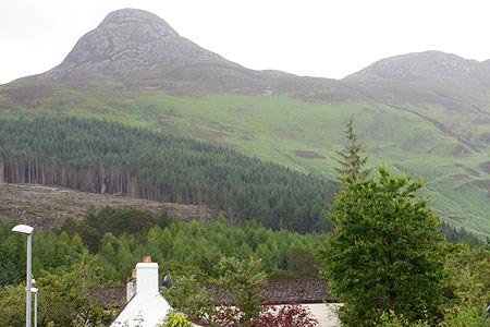
Click image to visit gallery of 6 images.
When it come to the height of Scottish mountains, bigger is not necessarily better and it is generally recognised among those who walk the Scottish hills that some Corbetts (between 2.500 and 3,000 feet) and Grahams (between 2,000 and 2,500 feet) provide more attractive mountains than some of the less appealing Munros. The Pap of Glencoe (2,434 feet) is a case in point. Seen a bit like a giant thimble overlooking the village of Glencoe, this is an isolated top that offers a fine viewpoint overlooking Loch Leven and Glencoe.
The only parking option near to the start of the walk is limited roadside parking, therefore starting from Glencoe village and walking for a mile along the road may be seen as a better option. Passing a private house on the left, turn off the road next to it to walk through a metal gate and follow a path leading straight uphill between bracken with the Pap of Glencoe peeping out over the highest point of the horizon directly ahead. The path branches right over a footbridge across a stream to the right and then winds its way up the felllside between heather and rocks, going on a diagonal traverse of the felllside with the Munro, Sgorr nam Fiannaidh, seen directly ahead. This Munro is the one of the two on the Aonach Eagach ridge to the west, though the actual top is further back and out of sight from here. In any case, this walk does not include it.
The path is steep in a few places and passes close to a gorge on the left. It follows a diagonal upwards traverse of the felllside with the Munro straight ahead and it seems a long time before it eventually changes course to turn left, with the dome shape of "The Pap" now seen directly ahead. Ignore a path off to the right which leads to the Munro and instead follow the path ahead with the bealach (col) the next objective. It now feels like progress is being made in earnest. At the col, at first sight, there is no obvious way up the rocky dome of "The Pap" although a glimpse of path can just be spotted to the right of it. There is a narrow path, steep and rocky that traverses diagonally up to the right, and a steadying hand may be required in places. When I did this walk In June 2012, at this point, the weather was threatening to take a turn for the worse and cloud was blowing across the col, sometimes blotting it completely from sight before clearing again. As it turned out, the rain which had been forecast did not arrive until near the conclusion of the walk and instead, the top was clear of both cloud and rain. The path emerges near the rocky summit plateau to reveal a small cairn at the top and some airy views of the surrounding landscape, particularly looking down on Loch Leven.
The lack of paths in the area means little choice in terms of route variation, and therefore the conclusion of the walk involves reversing the outgoing route.
Maps 

| Ordnance Survey Explorer 384 | Sheet Map | 1:25k | BUY |
| Anquet OS Explorer 384 | Digital Map | 1:25k | BUY |
| Ordnance Survey Digital Map Subscription | |||
| Latest Ordnance Survey Discounts | |||
Other walks nearby
| Walk 3118 | Sgor na h'Ulaidh from Achnachon, Glen Coe | mod/hard | 8.0 miles |
| Walk 2955 | Ridges & peaks of Bidean Nam Bian | very hard | 10.5 miles |
| Walk 2554 | The Lost Valley, Glen Coe | easy/mod | 4.2 miles |
| Walk 3251 | Bidean nam Bian via Stob Coire nan Lochan, Glencoe | hard | 5.0 miles |
| Walk 1496 | WHW - Day 6 - Kinlocheven to Fort William | moderate | 15.0 miles |
| Walk 3106 | Binnein Mor from Kinlochleven | hard | 10.2 miles |
| Walk 1039 | Am Bodach and Stob Coire a' Chairn | mod/hard | 9.5 miles |
| Walk 1094 | Blackwater Reservoir | moderate | 11.5 miles |
| Walk 2808 | Buachaille Etive Beag, Glen Coe | hard | 9.0 miles |
| Walk 3303 | Mamores Ridge - Stob Ban, Am Bodach and Sgurr an Iubhair | hard | 9.0 miles |
Recommended Books & eBooks
Skye's Cuillin Ridge Traverse
 This 2-volume set provides all the information required to complete the main ridge traverse on Skye's Black Cuillin. Strategy, gear, training, navigation and logistics are covered, and 10 classic scrambles are described. A lightweight second guidebook gives the scrambler detailed maps, topos and route description for the ridge traverse itself.
More information
Great Mountain Days in Scotland
 Inspirational guidebook to 50 challenging routes for mountaineers, scramblers, hillwalkers and fell runners, many long enough to backpack over 2 days, especially in winter (12 to 25 miles). A mix of classic routes and unsung gems across Scotland from Galloway to the Outer Hebrides in widely differing wild landscapes. With customised OS mapping.
More information
