Stocks Reservoir from Slaidburn
Forest of Bowland Walk
Region - Forest of Bowland
County/Area - Lancashire
Author - Lou Johnson
Length - 11.5 miles / 18.7 km Ascent - 1300 feet / 394 metres
Time - 7 hours 0 minutes Grade - moderate
Maps 

| Ordnance Survey Explorer OL41 | Sheet Map | 1:25k | BUY |
| Anquet OS Explorer OL41 | Digital Map | 1:25k | BUY |
| Ordnance Survey Landranger 103 | Sheet Map | 1:50k | BUY |
| Anquet OS Landranger 103 | Digital Map | 1:50k | BUY |
Walk Route Description
Click image to visit gallery of 12 images.
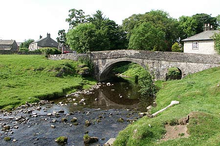
The Forest of Bowland offers a wide selection of walks in a variety of scenic contexts. This route starts from the attractive village of Slaidburn, which is worth further exploration, and complete a full circuit of the Stocks Reservoir, which was constructed in 1922 to provide water for Blackpool.
The start is the pay and display car park near the river in Slaidburn (Grid ref. SD714524). Exit the car park and turn right. Walk up to the war memorial in the village centre and turn right onto the road to Bentham. Just after crossing Croasdale Brook turn right onto the path beside the river. The path takes a short cut across meadows to reach the River Hodder at Holmehead Bridge (Grid ref. SD 715531). Cross the bridge and turn left and continue on the track to Hammerton Hall. Passing the Hall on your left bear left at the fork in the tracks (Grid ref. SD719539) and make the steady ascent onto Ten Acre Hill from where you see Stocks Reservoir for the first time.
The path drops down to pass to the left of Black House Farm where a gate allows you to join the main drive. This leads down to a minor road (Grid ref. SD736553). Turn left and pass the chapel on your right. Continue along this road, crossing a causeway over the reservoir, to reach a picnic site where the road turns sharp right (Grid ref. SD732565). Leave the road here and follow the path that shadows the reservoir shore to reach the edge of the plantation (Grid ref. SD725573).
The path crosses Hasgill Beck and soon after becomes a track and leads you up past derelict New House. Stay on this track (not marked on some OS maps) to reach another track at the head of Parks Clough (Grid ref. SD718586). Turn left here and descend to Lock Bridge where you cross the River Hodder. A gentle ascent along this track leads you past the hamlet of Kenibus to join a lane (Grid ref. SD708578). Turn left along this lane from where excellent views are to be had of the surrounding countryside.
Where the lane bends right (grid ref. SD710574) continue straight ahead on a track. This leads you onto the right of way that follows the track bed of the railway that was used during construction of the reservoir (Grid ref. SD713573). There were some signs in this area but they were rather confusing and the use of good map is probably a better to way of route finding. Once the old railway has been reached stay on this for over a mile. Reaching a sign (Grid ref. SD723559), bear right uphill. Keep left of the trees and a ruin, your reach another derelict building.
Keep this on your right and follow the developing path over a small bridge and up to the corner of a wood (Grid ref. SD716559). Continue on the occasionally waymarked route to reach the main drive (Grid ref. SD714556) to Hollins House. Turn right onto this drive to reach a road. Turn left here and walk over Sagar Hill to reach a signed drive to Shay House on your right (Grid ref. SD710546). Follow this drive towards Shay House turning left onto a signed footpath just before reaching Croasdale Brook.
This path takes a direct route across meadows beside the brook before climbing straight ahead over a hill. During the climb there are some excellent views behind you to the higher fells of the Forest of Bowland. Just over the summit of the hill the path turns half right to descend to a stile on the Bentham road. Turn right along the road, left at the war memorial and return through the village to the car park.
Other walks nearby
| Walk 3730 | Stocks Reservoir Circular | easy/mod | 7.0 miles |
| Walk 3505 | Whitewell via Crag Stones from Dunsop Bridge | easy/mod | 8.5 miles |
| Walk 2508 | Dunsop Fell & the Forest of Bowland | moderate | 10.0 miles |
| Walk 2510 | Totridge Fell via Langden & Bleadale Water | mod/hard | 10.0 miles |
| Walk 2555 | Whitendale from Dunsop Bridge | moderate | 8.0 miles |
| Walk 2556 | Whitendale & Dunsop Fell from Dunsop Bridge | mod/hard | 15.0 miles |
| Walk 2331 | Whin Fell & Ouster Rake from Dunsop Bridge | moderate | 8.3 miles |
| Walk 2437 | Bowland Knotts | moderate | 7.4 miles |
| Walk 2594 | Totridge Fell & Fiendsdale Head, Forest of Bowland | moderate | 11.0 miles |
| Walk 2384 | Hodder Valley from Whitewell | easy/mod | 6.8 miles |
Recommended Books & eBooks
Walking on the West Pennine Moors
 This guidebook describes 30 walks on the West Pennine Moors, around Blackburn, Darwen, Chorley and Bolton, home to some of the most inspiring and exhilarating walking country. The walks range from short, easy rambles to more challenging hikes covering a variety of terrain, all of it easily accessible for day walking.
More information
Walking in the Forest of Bowland and Pendle
 A guidebook to 40 diverse circular day walks suitable for walkers with navigational skills. The Forest of Bowland and Pendle are two of north west England's upland AONBs, perfect for walkers who enjoy exploring rough hilly, sometimes pathless terrain. The routes include Ward's Stone, Pendle Hill, Longridge Fell and Fair Snape Fell.
More information
Messaging & Social Media
Message Walking Britain and follow the latest news.

Mountain Weather
Stay safe on the mountains with detailed weather forecasts - for iOS devices or for Android devices.