Stocks Reservoir Circular
Forest of Bowland Walk
Region - Forest of Bowland
County/Area - Lancashire
Author - Lou Johnson
Length - 7.0 miles / 11.4 km Ascent - 700 feet / 212 metres
Time - 4 hours 10 minutes Grade - easy/mod
Walk Route Description
Click image to see photo description.
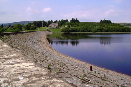
This circuit of Stocks Reservoir in the Forest of Bowland offers excellent and undemanding walking. The route makes an anti-clockwise circuit of the reservoir which was completed in 1932 providing water to Fylde Coast. During its construction around 500 men worked on the site with many bringing their families too. The walk follows a circular path created by the provision of concessionary footpaths to connect existing public footpaths.
The start is the School Lane car park (grid ref. SD732563) which lies on the minor road on the east side of the reservoir. The walk is a waymarked circular path which is generally easy to follow. After parking exit the car park and walk north on the waymarked path with the reservoir on your left. The path shadows the reservoir shore to reach the edge of the plantation (grid ref. SD726574). The onward path passes through farmland soon crossing Hasgill Beck. Continue north-west to reach derelict New House (grid ref. SD720580).
After New House, the waymarked route turns left and descends to cross the River Hodder on a footbridge. Maintain direction up Copped Hill Clough to reach a track after 800 metres (grid ref. SD713573). Turn left along the track and continue following the waymarked trail for 4.5 kilometres to reach the reservoir dam wall (grid ref. SD717547). Cross the dam to gain the eastern side of the reservoir where a concessionary path follows the shore to reach School Lane. Turn left and continue north back to the start.
Maps 

| Ordnance Survey Explorer OL41 | Sheet Map | 1:25k | BUY |
| Anquet OS Explorer OL41 | Digital Map | 1:25k | BUY |
| Ordnance Survey Digital Map Subscription | |||
| Latest Ordnance Survey Discounts | |||
Other walks nearby
| Walk 2437 | Bowland Knotts | moderate | 7.4 miles |
| Walk 2216 | Slaidburn Village Trail - Ribble Valley | easy | 0.8 miles |
| Walk 3329 | Stocks Reservoir from Slaidburn | moderate | 11.5 miles |
| Walk 2452 | Dunsop Head from Slaidburn | easy/mod | 7.0 miles |
| Walk 3505 | Whitewell via Crag Stones from Dunsop Bridge | easy/mod | 8.5 miles |
| Walk 2508 | Dunsop Fell & the Forest of Bowland | moderate | 10.0 miles |
| Walk 2510 | Totridge Fell via Langden & Bleadale Water | mod/hard | 10.0 miles |
| Walk 2555 | Whitendale from Dunsop Bridge | moderate | 8.0 miles |
| Walk 2556 | Whitendale & Dunsop Fell from Dunsop Bridge | mod/hard | 15.0 miles |
| Walk 2331 | Whin Fell & Ouster Rake from Dunsop Bridge | moderate | 8.3 miles |
Recommended Books & eBooks
Walking in the Forest of Bowland and Pendle
 A guidebook to 40 diverse circular day walks suitable for walkers with navigational skills. The Forest of Bowland and Pendle are two of north west England's upland AONBs, perfect for walkers who enjoy exploring rough hilly, sometimes pathless terrain. The routes include Ward's Stone, Pendle Hill, Longridge Fell and Fair Snape Fell.
More information
Walking on the West Pennine Moors
 This guidebook describes 30 walks on the West Pennine Moors, around Blackburn, Darwen, Chorley and Bolton, home to some of the most inspiring and exhilarating walking country. The walks range from short, easy rambles to more challenging hikes covering a variety of terrain, all of it easily accessible for day walking.
More information
