Walk 3365 - printer friendly version
Bosherston Lily Ponds, Broad Haven & St. Govan's Chapel Walk
Author - Lou Johnson
Length - 5.0 miles / 8.1 km
Ascent - 520 feet / 158 metres
Grade - easy/mod
Start - OS grid reference SR967948
Lat 51.6152190 + Long -4.9378709
Postcode SA71 5DN (approx. location only)
This walk from Bosherston includes a section of coastal walking, a visit to St. Govan's Chapel, the beach at Broad Haven and beautiful lily ponds. The route enters part of the Castle Martin firing range which is used for 44 weeks of the year when this route is closed for access. During holiday periods and some weekends, the route can be completed. For further information visit www.gov.uk/government/publications/castlemartin-firing-notice--2 or call 01646 662367 for recorded information. Whilst on the range DO NOT touch spent ammunition or any suspicious objects.
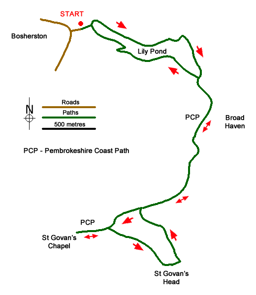
The start is the National Trust car park in Bosherston (grid ref. SR967948). From the car park take the concrete path that passes in front of the toilet blocks and continue ahead ignoring a path on the right. Continue to cross a causeway over the western end of the Lily Ponds. Reaching the other side, bear right and follow the path alongside the water. You soon reach a second causeway after which you bear right. Continue to and cross a third causeway. Continue along the clear path to reach a junction with a three-way fingerpost (grid ref. SR977944). Continue straight ahead down to the beach. Bear right over a wooden bridge and bear left onto the beach.
Bear right along the edge on the dunes and continue along the beach to reach a stepped path. At the top go through a gate and bear left through the car park. At the far end of the car park, pass through another gate to reach the cliff top. Turn left and follow the Pembrokeshire Coast Path along the cliffs with the sea on your left. Continue to reach a sentry cabin at the boundary of the firing range (grid ref. SR976936). If the range is closed retrace your steps and follow the instructions in the final paragraph.
Assuming the range is open, continue along the coast path which is some way back from the cliffs. Continue along the grassy track which soon curves to the left passing a bunker on the right. At the junction of tracks, turn right, with the bunker on your right, and continue to a cattle grid and gate which are just beyond another bunker also on your right. Just past the cattle grid bear left and follow the path around the cliff top to reach a rocky cleft where a short path descends left down to St Govan's Chapel.
After visiting the chapel, retrace your steps to the cattle grid. Bear right off the track and follow the path along the cliff tops. Follow this across Trevallen Downs all the way to St. Govan's Head where there is a viewing platform with a command post below. After enjoying the view, continue around the headland following one of the many paths along the edge of the cliffs. Descend to a track in a narrow valley and turn right. Where the track forks, bear right out of the valley to join the track used on the outward route. Continue back to the sentry box ((grid ref. SR976936).
Retrace your steps past the car park and back down to Broad Haven beach. Cross the beach to reach the wooden footbridge. Cross this and then a few metres later bear left to re-cross the stream on a concrete footbridge. Follow this path around the southern edge of the Lily Ponds. After passing the ruin of a pumphouse, bear to the left and climb back to the car park.
Messaging & Social Media
Message Walking Britain and follow the latest news.

Mountain Weather
Stay safe on the mountains with detailed weather forecasts - for iOS devices or for Android devices.