Holdstone Down & Trentishoe Walk
Walk 3394 - Route Maps & Profile
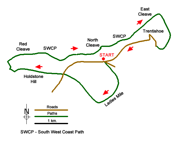
Route Map
Digital Maps - Copyright © 2011-2024. All rights reserved.
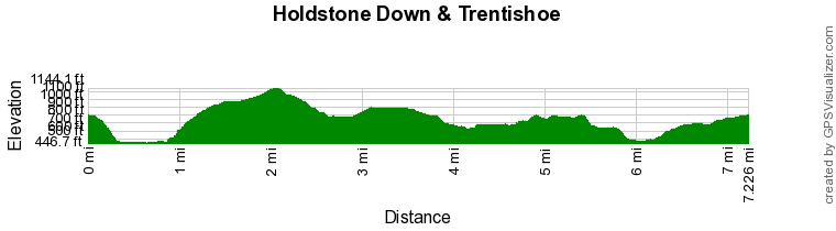
Route Profile
Sketch Map
Suggested Maps 

| Ordnance Survey Explorer OL9 | Sheet Map | 1:25k | BUY |
| Anquet OS Explorer OL9 | Digital Map | 1:25k | BUY |
| Ordnance Survey Digital Map Subscription | |||
| Latest Ordnance Survey Discounts | |||
It is recommended you take a map. The preferred scale is 1:25k.
Start Point Details
Ordnance Survey Grid Ref SS635480
Latitude 51.214839 Longitude -3.955732
Postcode EX31 4PL
what3words start noting.readjust.push
Walk description may contain detailed information on the start point for this walk.
Further Information
Exmoor
Walking in the Exmoor National Park, which lies in West Somerset and North Devon, includes a dramatic section of coast. Wild moorland dominates the high ground with Dunkery Beacon the highest point within the National Park. Wooded valleys or combes cut deep into this upland and provide another typical feature of the landscape. The coast includes some of the highest cliffs in the UK with easy access provided by the South West Coast National Trail. Exmoor Walking Guide
Devon
The County of Devon offers a wide range of walking. With two lengthy sections of coastal path along the north and south coasts the variety of walking on offer is hard to match anywhere in the British Isles. Add to this the wild moors of the Dartmoor National Park with the highest land in southern England and you soon realise why Devon has such a high reputation among walkers. Elsewhere there are many pretty villages to explore as well as vast tracts of rural farmland with a patchwork of fields surrounded by hedgerows.
Walk grading - Learn how each walk is assessed and select a walk to suit your ability and experience by going to Walk Grading Details.
Messaging & Social Media
Message Walking Britain and follow the latest news.

Mountain Weather
Stay safe on the mountains with detailed weather forecasts - for iOS devices or for Android devices.