Walk 3394 - printer friendly version
Holdstone Down & Trentishoe Walk
Author - Lou Johnson
Length - 7.0 miles / 11.4 km
Ascent - 1500 feet / 455 metres
Grade - moderate
Start - OS grid reference SS635480
Lat 51.2148390 + Long -3.9557320
Postcode EX31 4PL (approx. location only)
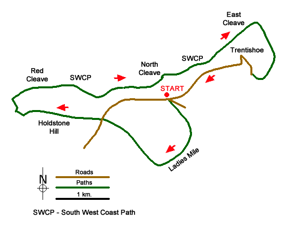
This varied North Devon walk from Trentishoe Down explores a typical wooded Exmoor valley, upland moors, and follows a section of the South West Coast Path along this beautiful coast. The route generally follows well-used paths, tracks, and country lanes. However, there are points along the route where a map would be useful.
The start is the car park on the north side of Trentishoe Down (grid ref. SS635480) which can be reached by leaving the A399 at Slade Lane Cross and following Coulsworthy Lane north to Stony Corner where you turn right for Trentishoe. From the carpark you can see along the coast which will be explored in greater detail later in the walk. After parking exit the car park, turn left and immediately fork right immediately getting wonderful view of the landscape ahead. You soon reach a footpath crossing the road. Turn right and follow the descending path into the valley. After 350 metres down a grassy path you reach a fork (grid ref. SS638476) where you bear right to follow the Ladies Mile Path.
Continue along the path which follows a level route with trees down to your left. After 800 metres the path forks (grid ref. SS636470) at a fingerpost. Fork right here and continue uphill on a clear path. Continue ahead keeping a small wood on your left to join a track (grid ref. SS631473). Follow this clear track uphill across the moor to reach a road (grid ref. SS625477). Cross the road and take the rising path opposite which leads to the summit of Holdstone Hill with its OS trig point.
After enjoying the view continue straight ahead (west) and descend the moor. Ignore a cross path and follow the path ahead as it bears left to meet a wider grassy path (grid ref. SS613477). Turn right to meet the South West Coast Path. Turn right onto the coast path which initially follows the contours some 700 feet above the sea. The walk continues to follow the South West Coast Path with an excellent view of the coast ahead. An OS map is useful so you can identify the various features passed along the path. After about four kilometres of superb walking you reach a path junction (grid ref. SS649492) where the South West Coast Path turns left. At this point bear right following the Tarka Trail.
Five hundred metres beyond this junction the Tarka Trail turns left to descend into the Heddon Valley. The route leaves the Traka Trail here and continues ahead at this junction to contour across the top of a steep hillside with the valley below on your left. Follow this path and continue to reach a lane below Trentishoe. Turn right and continue uphill through the village following the lane to pass a small church on your right. A steady climb up the lane for 800 metres takes you back to the car park used at the start.
Messaging & Social Media
Message Walking Britain and follow the latest news.

Mountain Weather
Stay safe on the mountains with detailed weather forecasts - for iOS devices or for Android devices.