Walk 3405 - printer friendly version
Abbots Bromley Circular Walk
Author - Lou Johnson
Length - 6.0 miles / 9.8 km
Ascent - 520 feet / 158 metres
Grade - easy
Start - OS grid reference SK080245
Lat 52.81798 + Long -1.8827372
Postcode WS15 3BP (approx. location only)
This short walk explores typical Staffordshire countryside immediately north of the village of Abbots Bromley, which has an ample number of pubs for refreshment at the end of the walk. The walk follows a section of the Staffordshire Way and skirts the edge of Bagot's Park. The village of Abbots Bromley is famous for its Horn Dance. Originating in August 1226, the dance is one of few rural customs to survive so many years and takes place annually on Wakes Monday attracting visitors from all over the world.
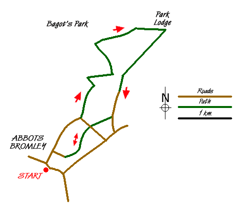
The start of this walk is the Market Place which lies on the B5014 in the centre of the village (grid ref. SK080245). After parking locate Schoolhouse Lane that runs north. Walk up this lane passing the school. Turn right down Swan Lane and continue to the end of this road. As you reach the end of the road bear left towards the right hand end of the houses to reach the start of the footpath. This is the Staffordshire Way and is marked as such.
The path goes half left across the first field and continues to cross stream before climbing quite steeply through more fields to reach an enclosed track. This leads to a lane (grid ref. SK089253). Turn left along the lane. Where the lane turns sharp left, take the track on your right. This enclosed lane soon reaches open fields. Care is required on this section. It is very easy to miss the point where the path bears half right (grid ref. SK088259). The OS Explorer map makes this clear. Once this problem has been overcome the path is easy to follow as it follows a zigzag route to reach a tarmac access drive (grid ref. SK090269).
Leave the Staffordshire Way and turn right onto this tarmac access drive. Continue along the tarmac past Bagot's Park to reach Park Lodge (grid ref. SK104272). Turn right through the gate opposite Park Lodge and with the hedge on your left walk down hill towards the wood (Gadsby's Plantation). Reaching the boundary of the wood, look out for a stile in the boundary fence on your right. Cross this and following the waymark go half right through the wood to exit on the other side in a field. The path follows the boundary hedge on your right.
Continue on the same line along the hedge ignoring the temptation to turn right towards Parkside Farm. By keeping straight ahead you pass through sheep pens and a gate to reach the access track to Parkside Farm (grid ref. SK098265). Turn left onto this track, cross a cattle grid and continue downhill to pass Moors Farm. From here the lane is tarmac and you should continue ahead to a stile on your right (grid ref. SK093255). Cross the stile and continue to another stile in the hedge on your left. Cross this and a small field to a track. Continue ahead to reach a lane (grid ref. SK089253). You have been here before so retrace your steps back to the start.
Messaging & Social Media
Message Walking Britain and follow the latest news.

Mountain Weather
Stay safe on the mountains with detailed weather forecasts - for iOS devices or for Android devices.