Ghyll Head & Strawberry Bank Circular
Lake District Walk
Nat Park - Lake District - Lake District Lesser Fells
County/Area - Cumbria
Author - Lou Johnson
Length - 7.6 miles / 12.4 km Ascent - 1100 feet / 333 metres
Time - 4 hours 50 minutes Grade - moderate
Maps 

| Ordnance Survey Explorer OL7 | Sheet Map | 1:25k | BUY |
| Anquet OS Explorer OL7 | Digital Map | 1:25k | BUY |
| Ordnance Survey Landranger 90 | Sheet Map | 1:50k | BUY |
| Anquet OS Landranger 90 | Digital Map | 1:50k | BUY |
Walk Route Description
Click image to see photo description.
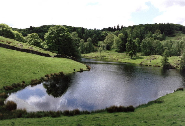
This Lake District walk explores to the east of Lake Windermere. The route starts from Ghyll Head Reservoir where there is limited parking (grid ref. SD 398924) on the north side of the lane leading up from the A592 about 2.5 miles south of Windermere. After parking walk east with the reservoir to your right and continue for a kilometre along the lane to reach a junction (grid ref. SD402914). Turn left signed to Winster and Kendal, ignoring the left fork just after the junction.
Continue over the hill and follow the lane down into a broad valley. Approaching The Oaks Farm just after the road bends left, take the signed public footpath on the right to Birks Road. Go through two gates and follow a track through the field. At the end of the field turn right (yellow waymark) and continue to the end of the field. Cross the stile on your left by a wooden gate. Continue up a rise to the right and go through an old gate next to a tree. Continue on a grassy track. Continue through a small gate and enter a yard by a cottage. Cross the lawn using the steppingstones (left of the cottage), join a narrow path, pass through a small gate, and cross the stile in the wall to your left. Pass the cottage on your right, continue up steps by the barn and go through a gate into a field.
Continue ahead following the path to another gate. Pass through the gate and cross the field to a ladder stile. Once across the stile, join a track and continue to a wood. On this section there is an excellent view of Windermere and the fells beyond. Continue over a stile and follow the path through the wood. Reaching a path junction, turn left following the yellow arrow up the hill. Continue ahead where a track goes off to the left. Reaching a clearing at the top of the hill there is great view to the left.
Leaving the clearing, continue along a narrow path descending through woodland. Cross the stile and continue through a muddy section and into a conifer plantation. Turn left at the building (grid ref. SD401891) and cross a stile into a field. Continue to the left a rocky knoll and head down the field to reach a lane. Go through the wooden gate, and head right to reach the road junction by Lightwood Country Guest House. Turn left and follow the lane for 800 metres to pass the rear of the Mason's Arms. Turn sharp left and pass the front of the pub. After 300 metres turn right onto a bridleway that leads to Hollins Farm. Continue between the house and barn. Go through a gate down the walled track. Cross a stream and continue ahead to reach a lane (grid ref. SD408906).
Turn right down the lane. After 250 metres take the bridleway on the left. Continue ahead to reach Wood Farm. As you approach Wood Farm you join a walled track. Continue past a barn to a T-junction. Turn right and continue to a lane (grid ref. SD412915). Bear left along the lane. Reaching a ford, turn left and cross the stream using the adjacent stone bridge. A few metres after crossing the bridge take the footpath on the right. Go through the kissing gate and follow a track across a field. Leave the track where it bends to the left and continue across to a stile over the wall. Continue past a broken wall, cross a stream, and then bear slightly left to a gate by some trees. Pass through the gate and follow a green lane.
Reaching the access drive to Winster House, turn left between the gateposts and follow the driveway around to the left. Continue by walking straight uphill along a stony track to a footpath. Reaching the top of this track, go through a gate, turn left and then immediately right to follow a path through Candlestick Moss, which leads you back to the start.
Other walks nearby
| Walk 3234 | Gummers How via Chapel House Wood, South Lake District | easy/mod | 5.5 miles |
| Walk 1417 | Astley's Plantation & Simpson's Ground | easy/mod | 7.5 miles |
| Walk 2053 | Claife Heights & Near Sawrey | easy | 2.5 miles |
| Walk 2143 | Whitbarrow & Lord's Seat | easy/mod | 5.4 miles |
| Walk 3451 | Underbarrow, Lord's Lot and Crossthwaite | easy/mod | 5.6 miles |
| Walk 3638 | Satterthwaite Bridge Circular | easy | 3.2 miles |
| Walk 3320 | Grizedale Tarn circular | easy | 2.5 miles |
| Walk 3590 | Orrest Head & Allen Knott from Windermere | easy | 4.4 miles |
| Walk 3410 | Latterbarrow from Hawkshead | easy | 4.0 miles |
| Walk 1463 | School Knott & Grandsire from Ings | easy/mod | 6.5 miles |
Recommended Books & eBooks
Lake District: Low Level and Lake Walks
 This guidebook describes 30 of the best low-level walks in the Lake District. From delightful wooded glades and sparkling tarns, to waterfalls and glacier-carved valleys towered over by craggy mountains. The walks described aim to seek out the best walking that the lower areas of the Lake District have to offer.
More information
Lake District: High Level and Fell Walks
 This guidebook describes 30 graded fell walks on the ridges and high peaks of the English Lake District, the UK's most popular national park. Reaching some of England's finest and highest mountain scenery, this guide leads readers to classic horseshoes and traditional ascents as well as lesser-known routes to quieter summits.
More information
Messaging & Social Media
Message Walking Britain and follow the latest news.

Mountain Weather
Stay safe on the mountains with detailed weather forecasts - for iOS devices or for Android devices.